Home > Europe > United Kingdom > Scotland > Edinburgh > Edinburgh
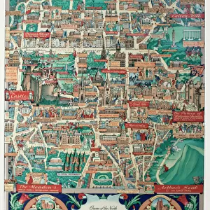
Chart of the North Atlantic, 1902. Creator: Unknown

![]()
Wall Art and Photo Gifts from Heritage Images
Chart of the North Atlantic, 1902. Creator: Unknown
Chart of the North Atlantic, 1902. Showing North and Central America, West Africa and Western Europe, and transatlantic shipping routes. From The Century Atlas of the World. [John Walker & Co, Ltd. London, 1902]
Heritage Images features heritage image collections
Media ID 15512438
© The Print Collector / Heritage-Images
Atlantic Ocean Canada Cartography Central America Edinburgh Geographical Institute Map Making North America Ocean Shipping Route Trade Route Transatlantic Mercator Projection
FEATURES IN THESE COLLECTIONS
> Africa
> Related Images
> Europe
> United Kingdom
> England
> London
> Related Images
> Europe
> United Kingdom
> Scotland
> Edinburgh
> Edinburgh
> Europe
> United Kingdom
> Scotland
> Lothian
> Edinburgh
> North America
> Canada
> Maps
> North America
> United States of America
> Related Images
EDITORS COMMENTS
This print showcases a Chart of the North Atlantic from 1902, created by an unknown cartographer. The intricate map depicts North and Central America, West Africa, Western Europe, and the transatlantic shipping routes that connected these regions during that era. Published in The Century Atlas of the World by John Walker & Co. , Ltd. in London, this piece offers a glimpse into the world's geography at the turn of the 20th century. The vibrant colors used to illustrate this chart bring life to each continent and ocean depicted. Crafted with precision and accuracy, it is evident that great care was taken in its creation. Utilizing a Mercator projection technique popular at the time for map making, this artwork provides viewers with an accurate representation of geographical features across vast distances. As we examine this historical artifact today, we can appreciate how it served as more than just a visual guide but also played a crucial role in facilitating trade between nations on both sides of the Atlantic Ocean. Transatlantic shipping routes are clearly marked on this chart - pathways that were vital for commerce and cultural exchange between countries such as Canada, United States of America, Europe, and others. Preserved by The Print Collector organization for future generations to admire and study, this remarkable piece allows us to reflect upon our interconnectedness throughout history while marveling at mankind's ability to navigate vast oceans using only maps like these.
MADE IN THE UK
Safe Shipping with 30 Day Money Back Guarantee
FREE PERSONALISATION*
We are proud to offer a range of customisation features including Personalised Captions, Color Filters and Picture Zoom Tools
SECURE PAYMENTS
We happily accept a wide range of payment options so you can pay for the things you need in the way that is most convenient for you
* Options may vary by product and licensing agreement. Zoomed Pictures can be adjusted in the Basket.