Greetings Card > Europe > United Kingdom > England > Sussex > Fishbourne
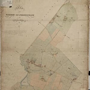
Greetings Card : New Fishbourne tithe map, 1839


![]()
Cards from West Sussex County Council
New Fishbourne tithe map, 1839
By C. Lewis, Havant. 26.6 in. to 1m. 49 × 37
Tithe Award Map Collection
West Sussex Record Office Ref No: TD/W87
West Sussex County Council Record Office contains a fascinating history of the county of West Sussex, England
Media ID 10716329
© West Sussex County Council - All Rights Reserved
1830s 19th Century Historical Mapping South Of England
Greetings Card (A5)
"Discover the rich history of West Sussex with our exclusive range of Media Storehouse Greeting Cards. This beautiful design features a captivating image of the New Fishbourne Tithe Map from 1839, originally held at the West Sussex Record Office. Add a touch of history to your correspondence with this unique, high-quality card. Perfect for any occasion. #WestSussex #History #GreetingCard"
Create your own greetings card. Size when folded is A5 (14.5x21cm or 5.7x8.3 inches)
Greetings Cards suitable for Birthdays, Weddings, Anniversaries, Graduations, Thank You and much more
Estimated Image Size (if not cropped) is 14.5cm x 21cm (5.7" x 8.3")
Estimated Product Size is 29cm x 21cm (11.4" x 8.3")
These are individually made so all sizes are approximate
Artwork printed orientated as per the preview above, with portrait (vertical) orientation to match the source image.
FEATURES IN THESE COLLECTIONS
> Europe
> United Kingdom
> England
> Maps
> Europe
> United Kingdom
> England
> Sussex
> Fishbourne
> Europe
> United Kingdom
> England
> Sussex
> Related Images
> Europe
> United Kingdom
> England
> West Sussex
> Related Images
> Maps and Charts
> Early Maps
> Maps and Charts
> Related Images
> West Sussex County Council
> West Sussex Record Office
> Tithe Award Maps, 1808-1859
EDITORS COMMENTS
This print showcases the New Fishbourne tithe map, a remarkable piece of historical mapping from the 19th century. Created by C. Lewis of Havant in 1839, this meticulously detailed map offers a fascinating glimpse into the past. Measuring at an impressive scale of 26.6 inches to 1 meter, it provides an intricate representation of the area's landscape and land ownership. Part of the esteemed Tithe Award Map Collection housed at West Sussex Record Office, this particular map holds immense value for researchers and history enthusiasts alike. Its reference number TD/W87 signifies its significance within the collection and highlights its importance as a primary source for studying land tenure during that era. The New Fishbourne tithe map sheds light on the socio-economic fabric of South England during the early 19th century. It reveals patterns of land use, boundaries between properties, and even names of individual owners or occupiers at that time. Such historical maps are invaluable resources for understanding how communities evolved over time and provide crucial insights into local history. It is important to note that this print is not associated with any commercial use but rather serves as a visual testament to our rich heritage preserved by West Sussex County Council. The dedication shown in preserving these historical artifacts allows us to appreciate our roots while offering valuable information for future generations seeking knowledge about their ancestors' lives and experiences in this region.
MADE IN THE UK
Safe Shipping with 30 Day Money Back Guarantee
FREE PERSONALISATION*
We are proud to offer a range of customisation features including Personalised Captions, Color Filters and Picture Zoom Tools
SECURE PAYMENTS
We happily accept a wide range of payment options so you can pay for the things you need in the way that is most convenient for you
* Options may vary by product and licensing agreement. Zoomed Pictures can be adjusted in the Basket.

![Chichester St. Peter the Great [Subdeanery] tithe map, 1846-1847](/sq/479/chichester-st-peter-great-subdeanery-tithe-10701869.jpg.webp)