Greetings Card > Sheffield City Archives > Maps and Plans > Bowen's County Maps, c. 1777
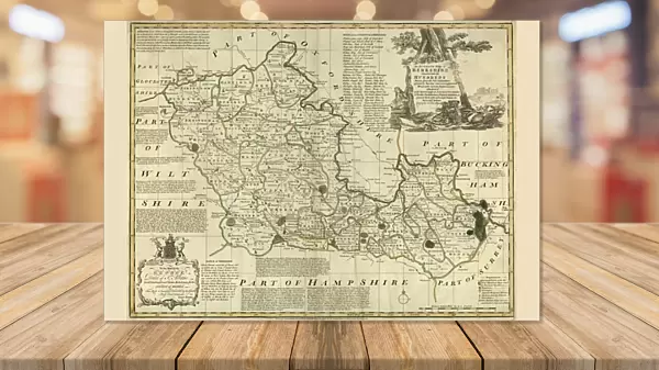
Greetings Card : County Map of Berkshire, c. 1777


![]()
Cards from Sheffield City Archives
County Map of Berkshire, c. 1777
From The Large English Atlas: or, a new set of map of all the counties of England and Wales drawn from the several surveys which have been hitherto been published. With three general maps of England, Scotland and Ireland, from the latest and best authorities, by Emanuel Bowen, Thomas Kitchin and others. London, printed and sold by T. Bowles, [c.1777]
Original at Sheffield Libraries: 912 STF
Sheffield City Archives and Local Studies Library has an unrivalled collection of images of Sheffield, England
Media ID 25437320
© Sheffield City Council - All Rights Reserved
Antique Map Bowens Map County Map Emanuel Bowen Old Map Thomas Kitchin Ascot Berkshire Bracknell Crowthorne Maidenhead Newbury Sandhurst Slough Thatcham Twyford Windsor Wokingham Woodley
Greetings Card (A5)
Introducing our latest addition to the Media Storehouse Greetings Cards collection: a unique and captivating design featuring a County Map of Berkshire from 1777. This exquisite card showcases an intricately detailed map taken from The Large English Atlas, archived in Sheffield City Archives. Travel back in time with this historical masterpiece and add a touch of nostalgia to your correspondence. Perfect for anniversary celebrations, milestone birthdays, or simply to brighten someone's day, our vintage-inspired greeting cards are sure to leave a lasting impression. Order yours today and experience the joy of sending history in a card!
Create your own greetings card. Size when folded is A5 (14.5x21cm or 5.7x8.3 inches)
Greetings Cards suitable for Birthdays, Weddings, Anniversaries, Graduations, Thank You and much more
Estimated Image Size (if not cropped) is 18.8cm x 14.5cm (7.4" x 5.7")
Estimated Product Size is 21cm x 29cm (8.3" x 11.4")
These are individually made so all sizes are approximate
Artwork printed orientated as per the preview above, with landscape (horizontal) orientation to match the source image.
EDITORS COMMENTS
This antique map, titled "County Map of Berkshire, c. 1777" takes us on a journey back in time to the picturesque landscapes and historic towns of this English county. Crafted by renowned cartographers Emanuel Bowen and Thomas Kitchin, this print is a true gem from "The Large English Atlas: or, a new set of maps of all the counties of England and Wales". As we gaze upon this beautifully detailed map, we are transported to the bustling streets of Reading, Slough, Bracknell, Maidenhead, Wokingham, Newbury, Woodley, Windsor and many other charming towns that dot the Berkshire countryside. The intricate illustrations showcase not only the main cities but also smaller settlements like Thatcham, Sandhurst, Crowthorne, and Ascot. Every stroke on this piece tells a story; it encapsulates an era when horse-drawn carriages traversed winding roads through lush green fields and ancient woodlands. This historical document provides invaluable insight into how Berkshire's landscape has evolved over centuries. Preserved with care at Sheffield Libraries' archives collection (912 STF), this original print offers an opportunity for history enthusiasts to delve into the past. It serves as a testament to the remarkable craftsmanship of its creators while providing researchers with valuable information about land boundaries and geographical features during that period. Let us cherish this exquisite work by Bowen and Kitchin as it allows us to appreciate both their artistry and our shared heritage.
MADE IN THE UK
Safe Shipping with 30 Day Money Back Guarantee
FREE PERSONALISATION*
We are proud to offer a range of customisation features including Personalised Captions, Color Filters and Picture Zoom Tools
SECURE PAYMENTS
We happily accept a wide range of payment options so you can pay for the things you need in the way that is most convenient for you
* Options may vary by product and licensing agreement. Zoomed Pictures can be adjusted in the Basket.