Greetings Card > Europe > United Kingdom > England > Maps
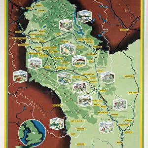
Greetings Card : Map / Derbyshire C1857


![]()
Cards from Mary Evans Picture Library
Map / Derbyshire C1857
Map of Derbyshire
Mary Evans Picture Library makes available wonderful images created for people to enjoy over the centuries
Media ID 4357693
© Mary Evans Picture Library 2015 - https://copyrighthub.org/s0/hub1/creation/maryevans/MaryEvansPictureID/10113966
Greetings Card (A5)
Introducing the latest addition to our Media Storehouse Greetings Cards collection: a charming design featuring an authentic map of Derbyshire from 1857. This exquisite card showcases the captivating details of Mary Evans Prints Online's "Map / Derbyshire C1857" image, bringing a touch of history and nostalgia to your correspondence. Whether you're sending a thoughtful message to a loved one or expressing your appreciation to a friend, this card is sure to leave a lasting impression. Add a personal touch by writing your message on the blank interior, and let the intricate map design do the talking. Bring history closer to home with our unique and beautifully designed greeting cards.
Create your own greetings card. Size when folded is A5 (14.5x21cm or 5.7x8.3 inches)
Greetings Cards suitable for Birthdays, Weddings, Anniversaries, Graduations, Thank You and much more
Estimated Image Size (if not cropped) is 14.5cm x 18.9cm (5.7" x 7.4")
Estimated Product Size is 29cm x 21cm (11.4" x 8.3")
These are individually made so all sizes are approximate
Artwork printed orientated as per the preview above, with portrait (vertical) orientation to match the source image.
FEATURES IN THESE COLLECTIONS
> Europe
> United Kingdom
> England
> Derbyshire
> Related Images
> Europe
> United Kingdom
> England
> Maps
> Europe
> United Kingdom
> England
> Posters
> Europe
> United Kingdom
> England
> Related Images
> Maps and Charts
> Early Maps
> Maps and Charts
> Related Images
EDITORS COMMENTS
This print of a Map of Derbyshire from 1857 offers a fascinating glimpse into the historical geography of England. The intricate details and delicate craftsmanship of this map transport us back in time to the mid-19th century, allowing us to explore the landscape and boundaries of Derbyshire as they were over 150 years ago.
From its rolling hills to its charming villages, this map captures the essence of Derbyshire with precision and artistry. Each line and symbol on the map tells a story of the region's past, offering insight into how people navigated and understood their surroundings during this era.
As we study this vintage map, we are reminded of the importance of cartography in shaping our understanding of place and history. Maps like these were not only practical tools for navigation but also works of art that reflected cultural values and political boundaries.
Whether you have personal ties to Derbyshire or simply appreciate historical artifacts, this Map / Derbyshire C1857 is sure to captivate your imagination and spark your curiosity about England's rich heritage. Display it proudly in your home or office as a conversation piece that celebrates both the beauty and complexity of our world.
MADE IN THE UK
Safe Shipping with 30 Day Money Back Guarantee
FREE PERSONALISATION*
We are proud to offer a range of customisation features including Personalised Captions, Color Filters and Picture Zoom Tools
SECURE PAYMENTS
We happily accept a wide range of payment options so you can pay for the things you need in the way that is most convenient for you
* Options may vary by product and licensing agreement. Zoomed Pictures can be adjusted in the Basket.