Greetings Card > Europe > Belgium > Aerial Views
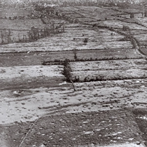
Greetings Card : Aerial view, Hollebeke, West Flanders, Belgium, WW1


![]()
Cards from Mary Evans Picture Library
Aerial view, Hollebeke, West Flanders, Belgium, WW1
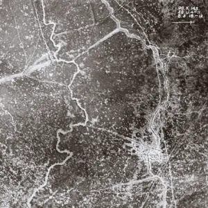
Aerial view of Hollebeke, near Ypres, West Flanders, Belgium, on 28 December 1917, a front line area with snow on the ground. The crossroads with canal and railway can be seen. The black specks are newly shelled areas. Date: 1917
Mary Evans Picture Library makes available wonderful images created for people to enjoy over the centuries
Media ID 14410472
© The Patricia Aubrey Collection / Mary Evans
Auerbach Belgian Corps Fields Harold Observation Reconnaissance Roads Squadron
Greetings Card (A5)
Step back in time with our poignant and historically rich Greetings Cards from Media Storehouse. This particular design features an aerial view of Hollebeke, West Flanders, Belgium, during the winter of 1917. Captured from Mary Evans Prints Online, this rights managed image offers a unique perspective of the front line area, complete with snow-covered ground, crossroads, canal, and railway. Perfectly suited for history enthusiasts or those sending thoughtful messages, this card is a unique and meaningful way to connect with loved ones.
Create your own greetings card. Size when folded is A5 (14.5x21cm or 5.7x8.3 inches)
Greetings Cards suitable for Birthdays, Weddings, Anniversaries, Graduations, Thank You and much more
Estimated Image Size (if not cropped) is 21cm x 14.5cm (8.3" x 5.7")
Estimated Product Size is 21cm x 29cm (8.3" x 11.4")
These are individually made so all sizes are approximate
Artwork printed orientated as per the preview above, with landscape (horizontal) orientation to match the source image.
FEATURES IN THESE COLLECTIONS
> Aerial Photography
> Belgium
> Aerial Photography
> Related Images
> Europe
> Belgium
> Aerial Views
> Europe
> Belgium
> Related Images
> Popular Themes
> Railway Posters
EDITORS COMMENTS
A Winter's Tale of War: An Aerial View of Hollebeke, West Flanders, Belgium during World War I This evocative aerial photograph, taken on 28 December 1917, offers a haunting glimpse into the harsh realities of the Western Front during the First World War. The scene unfolds above the small Belgian village of Hollebeke, situated near Ypres in West Flanders. The snow-covered landscape is punctuated by a network of roads and canals, including the intersection where the N365 road meets the Ypres-Comines Canal. The black specks scattered across the fields are the telltale signs of recently shelled areas, a grim reminder of the relentless conflict that raged on. The rural countryside, once a picturesque tableau of rolling hills and verdant fields, now bears the scars of war. In the background, the railway line snakes through the landscape, a vital artery for the transportation of troops and supplies. The Royal Flying Corps (RFC) squadrons, such as the Auerbach Squadron, conducted regular aerial reconnaissance and observation flights over the front lines, providing invaluable intelligence to the Allied forces. The photograph, taken by an unknown photographer, offers a unique perspective on the war, revealing the strategic importance of the region and the devastating impact of the conflict on the rural landscape. The image is a poignant reminder of the sacrifices made by the soldiers who fought in the mud and snow of the Western Front during the First World War.
MADE IN THE UK
Safe Shipping with 30 Day Money Back Guarantee
FREE PERSONALISATION*
We are proud to offer a range of customisation features including Personalised Captions, Color Filters and Picture Zoom Tools
SECURE PAYMENTS
We happily accept a wide range of payment options so you can pay for the things you need in the way that is most convenient for you
* Options may vary by product and licensing agreement. Zoomed Pictures can be adjusted in the Basket.