Greetings Card > Maps and Charts > Related Images
Greetings Card : Map of Europe showing how it appeared in the year AD 1360


![]()
Cards from MapSeeker
Map of Europe showing how it appeared in the year AD 1360
EHIST007
Welcome to the Mapseeker Image library and enter an historic gateway to one of the largest on-line collections of Historic Maps, Nostalgic Views, Vista's and Panorama's from a World gone by.
Media ID 20348256
Europe Europe Map Map Of Europe
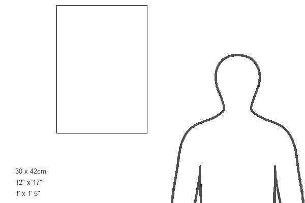
Greetings Card Large (A4)
Step back in time with our exquisite selection of Media Storehouse Greeting Cards (EHIST007). Each card features a captivating image of Europe as it appeared in AD 1360, meticulously recreated from the ancient MapSeeker map. Delve into history and transport your loved ones to a world of discovery and wonder. Perfect for history enthusiasts, anniversaries, or anyone who appreciates the beauty of the past. Send a piece of history with every greeting.
Create your own large greetings card. Size when folded is A4 (21x30cm or 8.3x11.7 inches)
Greetings Cards suitable for Birthdays, Weddings, Anniversaries, Graduations, Thank You and much more
Estimated Image Size (if not cropped) is 29.7cm x 21cm (11.7" x 8.3")
Estimated Product Size is 29.7cm x 42cm (11.7" x 16.5")
These are individually made so all sizes are approximate
Artwork printed orientated as per the preview above, with landscape (horizontal) orientation to match the source image.
FEATURES IN THESE COLLECTIONS
> Maps and Charts
> Related Images
> MapSeeker
> Maps of Europe
> Old Maps of Europe and Small Islands of
EDITORS COMMENTS
This print showcases a historically significant artifact, the "Map of Europe showing how it appeared in the year AD 1360". A true treasure for history enthusiasts and cartography aficionados alike, this map offers a fascinating glimpse into the geopolitical landscape of medieval Europe. With intricate details and vibrant colors, the map vividly depicts the diverse kingdoms, principalities, and city-states that dotted the continent during this pivotal period. From England to Byzantium, from Scandinavia to Italy, every corner of Europe is meticulously illustrated with precision and artistry. The year 1360 was marked by political turmoil and shifting alliances across Europe. As you explore this remarkable piece of history through your eyes or fingertips, immerse yourself in an era when feudalism reigned supreme and monarchies vied for power. Trace trade routes along bustling rivers like the Rhine or Danube; marvel at fortified castles guarding strategic mountain passes; discover ancient cities steeped in rich cultural heritage. Beyond its aesthetic appeal lies a deeper narrative waiting to be unraveled. This map serves as a gateway to understanding historical events such as Hundred Years' War between England and France or conflicts arising from religious schisms within Christianity. Whether you are an amateur historian seeking knowledge or simply captivated by European geography throughout time, this print will transport you back to an age where empires rose and fell against a backdrop of ever-changing borders. Let your imagination soar as you delve into this mesmerizing snapshot of medieval Europe's complex tapestry
MADE IN THE UK
Safe Shipping with 30 Day Money Back Guarantee
FREE PERSONALISATION*
We are proud to offer a range of customisation features including Personalised Captions, Color Filters and Picture Zoom Tools
SECURE PAYMENTS
We happily accept a wide range of payment options so you can pay for the things you need in the way that is most convenient for you
* Options may vary by product and licensing agreement. Zoomed Pictures can be adjusted in the Basket.