Greetings Card > Arts > Artists > T > John Tallis
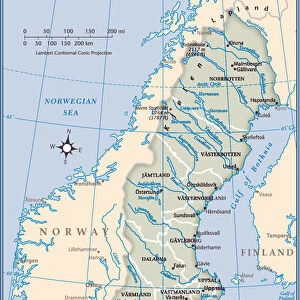
Greetings Card : Sweden & Norway 1851


![]()
Cards from MapSeeker
Sweden & Norway 1851
A fine facimile artworked from an antique original map of Sweden and Norway, issued as part of the 1851 edition of John Tallis and Companys " The Illustrated Atlas and Modern History of the World"
Welcome to the Mapseeker Image library and enter an historic gateway to one of the largest on-line collections of Historic Maps, Nostalgic Views, Vista's and Panorama's from a World gone by.
Media ID 20347521
© Mapseeker Publishing Ltd
John Tallis John Tallis Map Tallis Map
Greetings Card (A5)
Step into the past with our exquisite selection of greeting cards from Media Storehouse. This particular design showcases a stunning facsimile artwork of Sweden and Norway, as depicted in the 1851 edition of John Tallis and Company's "The Illustrated Atlas." Meticulously reproduced from the original map by John Tallis and John Rapkin of MapSeeker, this captivating image transports you back in time. Send a piece of history with these beautifully crafted greeting cards and add a touch of vintage charm to your correspondence. Perfect for anniversaries, birthdays, or simply to brighten someone's day, our collection of antique map greeting cards is sure to leave a lasting impression.
Create your own greetings card. Size when folded is A5 (14.5x21cm or 5.7x8.3 inches)
Greetings Cards suitable for Birthdays, Weddings, Anniversaries, Graduations, Thank You and much more
Estimated Image Size (if not cropped) is 14.5cm x 21cm (5.7" x 8.3")
Estimated Product Size is 29cm x 21cm (11.4" x 8.3")
These are individually made so all sizes are approximate
Artwork printed orientated as per the preview above, with portrait (vertical) orientation to match the source image.
FEATURES IN THESE COLLECTIONS
> Arts
> Artists
> T
> John Tallis
> Europe
> Norway
> Related Images
> Europe
> Sweden
> Related Images
> Maps and Charts
> Related Images
> MapSeeker
> Maps of Europe
> Maps of Scandinavia PORTFOLIO
EDITORS COMMENTS
This stunning print showcases a fine facsimile artworked from an antique original map of Sweden and Norway, dating back to 1851. The map was originally issued as part of the renowned 1851 edition of John Tallis and Company's "The Illustrated Atlas and Modern History of the World". Capturing the essence of historical cartography, this piece offers a glimpse into the past, allowing us to explore the intricate details that shaped these Scandinavian countries. With its delicate lines and exquisite craftsmanship, it transports us to a bygone era when maps were meticulously hand-drawn. The map highlights not only Sweden and Norway but also provides valuable insights into their respective regions during that period. It serves as a testament to John Tallis' expertise in creating visually appealing yet informative maps. As we admire this old Swedish and Norwegian map, we can't help but marvel at how geography has evolved over time. It reminds us of our connection with history and invites us to appreciate the rich cultural heritage embedded within these nations. Whether you are an avid collector or simply fascinated by vintage cartography, this print is sure to be a cherished addition to your collection. Its timeless beauty will undoubtedly spark conversations about both the artistic prowess behind its creation and the historical significance it represents.
MADE IN THE UK
Safe Shipping with 30 Day Money Back Guarantee
FREE PERSONALISATION*
We are proud to offer a range of customisation features including Personalised Captions, Color Filters and Picture Zoom Tools
SECURE PAYMENTS
We happily accept a wide range of payment options so you can pay for the things you need in the way that is most convenient for you
* Options may vary by product and licensing agreement. Zoomed Pictures can be adjusted in the Basket.