Greetings Card > Arts > Artists > T > John Tallis
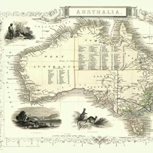
Greetings Card : Part of South Australia 1851


![]()
Cards from MapSeeker
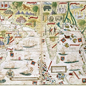
Part of South Australia 1851
A fine facimile artworked from an antique original map of Part of South Australia, issued as part of the 1851 edition of John Tallis and Companys " The Illustrated Atlas and Modern History of the World"
Welcome to the Mapseeker Image library and enter an historic gateway to one of the largest on-line collections of Historic Maps, Nostalgic Views, Vista's and Panorama's from a World gone by.
Media ID 20347342
© Mapseeker Publishing Ltd
Historic Map John Tallis John Tallis Map Tallis Map South Australia Southern Australia
Greetings Card (A5)
Introducing the Media Storehouse range of exquisite greeting cards, featuring a captivating reproduction of Part of South Australia, 1851 by John Tallis and John Rapkin from MapSeeker. This fine facsimile artwork brings the rich history of South Australia to life, transporting you back in time with its intricate details and antique charm. Perfect for those who appreciate the beauty of historical maps and the art of cartography, these greeting cards are a thoughtful and unique way to express your sentiments. Whether for a special occasion or just to brighten someone's day, our South Australia greeting cards are sure to leave a lasting impression. Order yours today and add a touch of history to your correspondence.
Create your own greetings card. Size when folded is A5 (14.5x21cm or 5.7x8.3 inches)
Greetings Cards suitable for Birthdays, Weddings, Anniversaries, Graduations, Thank You and much more
Estimated Image Size (if not cropped) is 14.5cm x 21cm (5.7" x 8.3")
Estimated Product Size is 29cm x 21cm (11.4" x 8.3")
These are individually made so all sizes are approximate
Artwork printed orientated as per the preview above, with portrait (vertical) orientation to match the source image.
FEATURES IN THESE COLLECTIONS
> Arts
> Artists
> T
> John Tallis
> Maps and Charts
> Related Images
> Maps and Charts
> World
> MapSeeker
> Maps of Africa and Oceana
> Old Maps of Australia PORTFOLIO
EDITORS COMMENTS
This print showcases a remarkable piece of history - a fine facsimile artworked from an antique original map of Part of South Australia, dating back to 1851. This exquisite map was originally issued as part of the renowned 1851 edition of John Tallis and Company's "The Illustrated Atlas and Modern History of the World". Transporting us back in time, this old map offers a glimpse into the past, revealing the intricate details and boundaries that shaped South Australia during this era. The delicate craftsmanship and precision evident in every stroke highlight the dedication with which cartographers like John Tallis approached their work. With its faded hues and weathered edges, this historic map evokes nostalgia for a bygone era. It serves as a testament to both the artistry involved in creating such maps and their invaluable role in documenting our world's evolution over time. John Rapkin's contribution to this masterpiece cannot be overlooked either; his expertise undoubtedly played an integral role in bringing forth such an accurate depiction of Southern Australia. Together, Tallis and Rapkin have left behind a legacy that continues to captivate historians, geographers, and enthusiasts alike. As we gaze upon this print today, let us appreciate not only its aesthetic appeal but also its significance as a tangible link to our past. It reminds us that beneath modern landscapes lie layers upon layers of history waiting to be discovered anew.
MADE IN THE UK
Safe Shipping with 30 Day Money Back Guarantee
FREE PERSONALISATION*
We are proud to offer a range of customisation features including Personalised Captions, Color Filters and Picture Zoom Tools
SECURE PAYMENTS
We happily accept a wide range of payment options so you can pay for the things you need in the way that is most convenient for you
* Options may vary by product and licensing agreement. Zoomed Pictures can be adjusted in the Basket.