Greetings Card > North America > United States of America > Maps
Greetings Card : Historical World Events map 1932 US version


![]()
Cards from Map Marketing
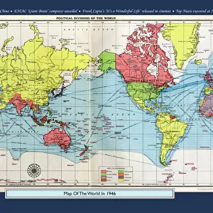
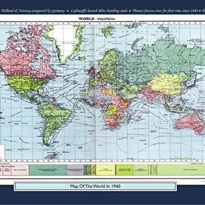
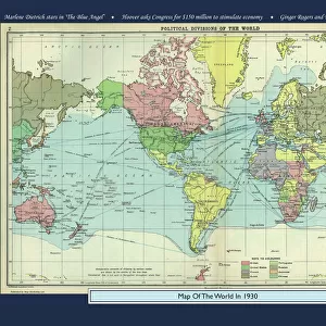
Historical World Events map 1932 US version
A world map originally published in 1932, reproduced from the internationally famousCollins Bartholomew World Through Timehistoric cartographic archive. A perfect reminder of how the world looked in 1932. The map is framed in a stylish text border containing highlights of significant events from 1932
Media ID 19959591
© Design Map Marketing Ltd, Mapping Collins Bartholomew
Greetings Card (A5)
Create your own greetings card. Size when folded is A5 (14.5x21cm or 5.7x8.3 inches)
Greetings Cards suitable for Birthdays, Weddings, Anniversaries, Graduations, Thank You and much more
Estimated Image Size (if not cropped) is 21cm x 14.5cm (8.3" x 5.7")
Estimated Product Size is 21cm x 29cm (8.3" x 11.4")
These are individually made so all sizes are approximate
Artwork printed orientated as per the preview above, with landscape (horizontal) orientation to match the source image.
FEATURES IN THESE COLLECTIONS
> Maps and Charts
> Early Maps
> Maps and Charts
> Related Images
> Maps and Charts
> World
> North America
> United States of America
> Maps
> Map Marketing
> Historical World Maps
MADE IN THE UK
Safe Shipping with 30 Day Money Back Guarantee
FREE PERSONALISATION*
We are proud to offer a range of customisation features including Personalised Captions, Color Filters and Picture Zoom Tools
SECURE PAYMENTS
We happily accept a wide range of payment options so you can pay for the things you need in the way that is most convenient for you
* Options may vary by product and licensing agreement. Zoomed Pictures can be adjusted in the Basket.