Greetings Card > Arts > Artists > W > Frederick de Wit
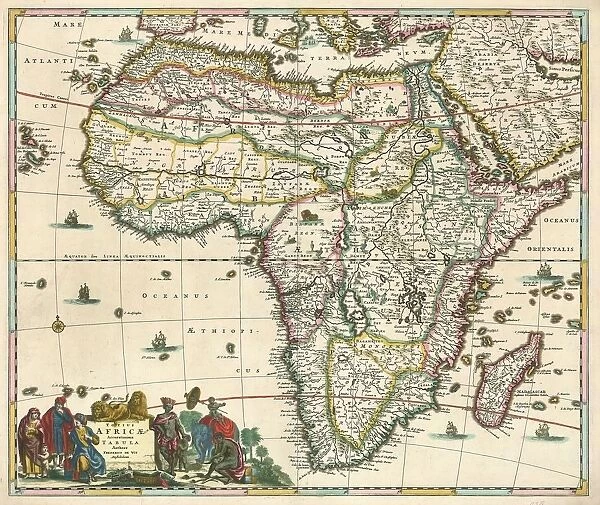
Greetings Card : Map Totius Africae accuratissima tabula Frederick de Wit
![]()

Cards from Liszt Collection
Map Totius Africae accuratissima tabula Frederick de Wit
Map, Totius Africae accuratissima tabula, Frederick de Wit (1630-1706), Copperplate print
Liszt Collection of nineteenth-century engravings and images to browse and enjoy
Media ID 19587483
© Artokoloro
1630 1706 Copperplate Print Frederick De Wit
Greetings Card Large (A4)
Discover the wonders of Africa with Media Storehouse's exquisite range of greeting cards. Featuring the intricately detailed and historically significant map, "Totius Africae accuratissima tabula," by renowned Dutch cartographer Frederick de Wit (1630-1706), these cards transport you on a journey across the vast and diverse landscapes of the African continent. Each card is meticulously printed from a copperplate, ensuring the finest quality and most authentic representation of this iconic map from the Liszt Collection. Perfect for any occasion, these unique and thoughtful cards are sure to leave a lasting impression.
Create your own large greetings card. Size when folded is A4 (21x30cm or 8.3x11.7 inches)
Greetings Cards suitable for Birthdays, Weddings, Anniversaries, Graduations, Thank You and much more
Estimated Image Size (if not cropped) is 29.7cm x 21cm (11.7" x 8.3")
Estimated Product Size is 29.7cm x 42cm (11.7" x 16.5")
These are individually made so all sizes are approximate
Artwork printed orientated as per the preview above, with landscape (horizontal) orientation to match the source image.
FEATURES IN THESE COLLECTIONS
> Arts
> Artists
> W
> Frederick de Wit
> Maps and Charts
> Related Images
EDITORS COMMENTS
This print showcases the exquisite "Map Totius Africae accuratissima tabula" by Frederick de Wit, a renowned cartographer from the 17th century. Crafted with utmost precision and attention to detail, this copperplate print transports us back in time to an era of exploration and discovery. De Wit's map is a true masterpiece, depicting the vast continent of Africa in all its glory. Every contour, river, mountain range, and coastline has been meticulously rendered on this stunning piece of art. The intricate craftsmanship allows us to immerse ourselves in the rich history and geography of Africa. As we gaze upon this remarkable print, we are reminded of De Wit's immense talent as a cartographer. His ability to capture the essence of Africa's diverse landscapes and accurately represent them on paper is truly awe-inspiring. The Liszt Collection has preserved this extraordinary work for generations to come. Through their dedication to showcasing historical treasures like De Wit's map, they allow us to appreciate not only the beauty but also the significance of these artifacts. Whether you are an avid collector or simply fascinated by African history and geography, this print serves as a window into another world. It invites you to explore every inch of Africa through De Wit's eyes and discover its hidden wonders for yourself.
MADE IN THE UK
Safe Shipping with 30 Day Money Back Guarantee
FREE PERSONALISATION*
We are proud to offer a range of customisation features including Personalised Captions, Color Filters and Picture Zoom Tools
SECURE PAYMENTS
We happily accept a wide range of payment options so you can pay for the things you need in the way that is most convenient for you
* Options may vary by product and licensing agreement. Zoomed Pictures can be adjusted in the Basket.


