Greetings Card > Europe > United Kingdom > England > Maps
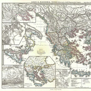
Greetings Card : Map of England Showing the Anglo-Saxon Kingdoms and Danish Districts


![]()
Cards from Liszt Collection
Map of England Showing the Anglo-Saxon Kingdoms and Danish Districts
Liszt Collection of nineteenth-century engravings and images to browse and enjoy
Media ID 12978366
© Quint Lox Limited
Anglo Saxon Danish Districts Kingdoms Plan Showing
Greetings Card (A5)
Introducing the captivating selection of greeting cards from Media Storehouse, featuring the intricately detailed "Map of England Showing the Anglo-Saxon Kingdoms and Danish Districts" by 000031 from the renowned Liszt Collection. Transport your recipients to the rich historical tapestry of early English history with this beautifully rendered map, meticulously illustrating the Anglo-Saxon kingdoms and Danish districts. This exquisite card design offers a unique and thoughtful way to celebrate a love of history, a special occasion, or simply to brighten someone's day. With premium quality paper and vibrant, long-lasting colors, our greeting cards are sure to leave a lasting impression. Add a personal touch with a heartfelt message and make every moment memorable. Order yours today and let history come alive in your hands.
Create your own greetings card. Size when folded is A5 (14.5x21cm or 5.7x8.3 inches)
Greetings Cards suitable for Birthdays, Weddings, Anniversaries, Graduations, Thank You and much more
Estimated Image Size (if not cropped) is 14.5cm x 21cm (5.7" x 8.3")
Estimated Product Size is 29cm x 21cm (11.4" x 8.3")
These are individually made so all sizes are approximate
Artwork printed orientated as per the preview above, with portrait (vertical) orientation to match the source image.
FEATURES IN THESE COLLECTIONS
> Europe
> Denmark
> Related Images
> Europe
> United Kingdom
> England
> Maps
> Maps and Charts
> Related Images
> Liszt Collection
> Engravings
> Nineteenth Century Engraving
EDITORS COMMENTS
This nineteenth-century engraving titled "Map of England Showing the Anglo-Saxon Kingdoms and Danish Districts" takes us on a journey back in time to explore the rich history of England. The intricately detailed map showcases the various Anglo-Saxon kingdoms and Danish districts that once shaped the landscape of this ancient land. With its retro-styled vintage appeal, this engraved image is not only a testament to Victorian arts and culture but also an illustrative technique that transports us into a bygone era. The engravement technique used in creating this print adds depth and texture, enhancing our visual experience as we study each kingdom and district meticulously depicted on the map. The Map of England serves as both a plan and chart, allowing us to delve into historical narratives while appreciating its artistic value. It offers a glimpse into how boundaries were drawn during that period, shedding light on political dynamics between different regions. As we observe this piece from Liszt Collection's vast archives, we are reminded of the importance of preserving cultural heritage through art. This print invites us to reflect upon our roots, fostering an appreciation for history's role in shaping our present-day society. Whether you are an avid historian or simply captivated by vintage aesthetics, this enchanting depiction will undoubtedly spark curiosity about England's past and leave you yearning for more knowledge about these fascinating Anglo-Saxon kingdoms and Danish districts.
MADE IN THE UK
Safe Shipping with 30 Day Money Back Guarantee
FREE PERSONALISATION*
We are proud to offer a range of customisation features including Personalised Captions, Color Filters and Picture Zoom Tools
SECURE PAYMENTS
We happily accept a wide range of payment options so you can pay for the things you need in the way that is most convenient for you
* Options may vary by product and licensing agreement. Zoomed Pictures can be adjusted in the Basket.