Greetings Card > Animals > Birds > Charadriiformes > Laridae > Pacific Gull
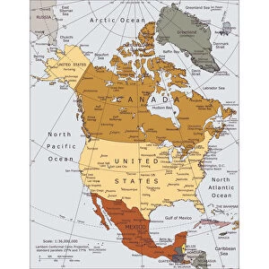
Greetings Card : Map of North America, c1910. Artist: Gull Engraving Company
![]()

Cards from Heritage Images
Map of North America, c1910. Artist: Gull Engraving Company
Map of North America, c1910. [Encyclopaedia Britannica Co]
Heritage Images features heritage image collections
Media ID 14975614
Border Gull Engraving Gull Engraving Co Gull Engraving Company North America Pacific Ocean
Greetings Card (A5)
Step back in time with our vintage-inspired greeting cards from Media Storehouse. This exquisite design features a captivating map of North America, dating back to 1910. The intricate detailing and authentic antique look are brought to you by the renowned Gull Engraving Company, sourced from Heritage Images and Encyclopaedia Britannica Co. Add a touch of history and nostalgia to your correspondence with these unique, collectible greeting cards. Perfect for anniversary celebrations, milestone birthdays, or simply to brighten someone's day, our Map of North America greeting cards are a thoughtful and distinctive choice for any occasion.
Create your own greetings card. Size when folded is A5 (14.5x21cm or 5.7x8.3 inches)
Greetings Cards suitable for Birthdays, Weddings, Anniversaries, Graduations, Thank You and much more
Estimated Image Size (if not cropped) is 14.5cm x 21cm (5.7" x 8.3")
Estimated Product Size is 29cm x 21cm (11.4" x 8.3")
These are individually made so all sizes are approximate
Artwork printed orientated as per the preview above, with portrait (vertical) orientation to match the source image.
FEATURES IN THESE COLLECTIONS
> Animals
> Birds
> Charadriiformes
> Laridae
> Pacific Gull
> Arts
> Artists
> O
> Oceanic Oceanic
> Maps and Charts
> Related Images
> North America
> United States of America
> Maps
EDITORS COMMENTS
This print showcases a stunning "Map of North America" from the early 20th century, specifically around 1910. Created by the talented Gull Engraving Company, this intricate piece of art beautifully captures the essence and grandeur of the continent. The vibrant colors used in this print bring to life each country and border, making it a true visual delight. The map focuses on North America's vastness, stretching from coast to coast with the Pacific Ocean serving as its majestic backdrop. Every detail is meticulously engraved, highlighting key locations and landmarks throughout the continent. One cannot help but marvel at the precision and skill employed by Gull Engraving Company in creating such an exquisite representation of North America. As we delve into this historical snapshot, we are transported back to a time when borders were different yet equally significant. The United States of America stands out prominently within this map as one of its most prominent nations during that era. Preserved through time, this remarkable print offers us a glimpse into American history while also serving as a testament to human creativity and craftsmanship. It is truly an invaluable treasure for any collector or enthusiast seeking to explore our rich heritage through artful lenses like those provided by Gull Engraving Company.
MADE IN THE UK
Safe Shipping with 30 Day Money Back Guarantee
FREE PERSONALISATION*
We are proud to offer a range of customisation features including Personalised Captions, Color Filters and Picture Zoom Tools
SECURE PAYMENTS
We happily accept a wide range of payment options so you can pay for the things you need in the way that is most convenient for you
* Options may vary by product and licensing agreement. Zoomed Pictures can be adjusted in the Basket.


