Greetings Card > Aerial Photography > England
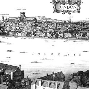
Greetings Card : Map of London featuring Whitefriars, 1682 (1930). Artist: Morden & Lea
. Artist: Morden & Lea")


. Artist: Morden & Lea")


![]()
Cards from Heritage Images
Map of London featuring Whitefriars, 1682 (1930). Artist: Morden & Lea
Map of London featuring Whitefriars, 1682 (1930). From Apollo magazine, volume XII, no 71 (November 1930)
Heritage Images features heritage image collections
Media ID 14923283
© The Print Collector / Heritage-Images
Aerial View Apollo Bridewell Prison Fleet Street Glass Works Glassworks Penitentiary Prison Thames Print Collector7 Whitefriars
Greetings Card (A5)
Step back in time with our exquisite greeting cards from Media Storehouse. This charming design features a detailed map of London, as it looked in 1682, recreated by Morden & Lea in 1930. The intricate illustration highlights Whitefriars, a historic area rich in history and culture. Perfect for those who appreciate the beauty of the past, this card is a thoughtful and unique way to send a message. Bringing a piece of history into your present, our vintage greeting cards are a must-have for any occasion.
Create your own greetings card. Size when folded is A5 (14.5x21cm or 5.7x8.3 inches)
Greetings Cards suitable for Birthdays, Weddings, Anniversaries, Graduations, Thank You and much more
Estimated Image Size (if not cropped) is 14.5cm x 21cm (5.7" x 8.3")
Estimated Product Size is 29cm x 21cm (11.4" x 8.3")
These are individually made so all sizes are approximate
Artwork printed orientated as per the preview above, with portrait (vertical) orientation to match the source image.
FEATURES IN THESE COLLECTIONS
> Aerial Photography
> England
> Aerial Photography
> Related Images
> Arts
> Artists
> Related Images
> Arts
> Landscape paintings
> Waterfall and river artworks
> River artworks
> Arts
> Literature
> Magazines
> Arts
> Minimalist artwork
> Monochrome artwork
> Fine art
> Arts
> Minimalist artwork
> Monochrome artwork
> Monochrome paintings
> Arts
> Portraits
> Pop art gallery
> Street art portraits
> Europe
> United Kingdom
> England
> Aerial Views
> Europe
> United Kingdom
> England
> London
> River Thames
EDITORS COMMENTS
This print takes us back in time to the bustling streets of 17th century London. The Map of London featuring Whitefriars, created by Morden & Lea in 1682 but printed in 1930, offers a unique aerial view of this historical city. The River Thames gracefully winds its way through the heart of London, dividing the land into distinct sections. Fleet Street, known for its vibrant newspaper industry at the time, stands out prominently with its array of buildings and busy street life. Bridewell Prison looms nearby, serving as a reminder of the city's crime-ridden past. One cannot help but be drawn to the Whitefriars Glassworks factory nestled along one side of this map. Its presence signifies an era when glass production was thriving and plays a significant role in understanding London's industrial history. The monochrome aesthetic adds an air of nostalgia to this print, transporting viewers back to the early 20th century when it was featured in Apollo magazine. It serves as both a geographical feature and a piece of art that captures London's essence during two different centuries. As we gaze upon this remarkable image, we are reminded not only of how much has changed over time but also how certain landmarks have stood the test of time. Morden & Lea's creation allows us to appreciate both the beauty and complexity that make up England's capital city - from its winding lanes to grand avenues - all within one captivating frame.
MADE IN THE UK
Safe Shipping with 30 Day Money Back Guarantee
FREE PERSONALISATION*
We are proud to offer a range of customisation features including Personalised Captions, Color Filters and Picture Zoom Tools
SECURE PAYMENTS
We happily accept a wide range of payment options so you can pay for the things you need in the way that is most convenient for you
* Options may vary by product and licensing agreement. Zoomed Pictures can be adjusted in the Basket.