Greetings Card > North America > United States of America > Louisiana > New Orleans
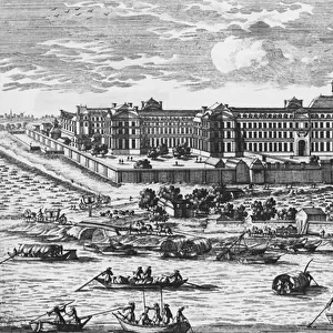
Greetings Card : Plan of New Orleans, Louisiana, 1718-1720: engraving, French, 1753


![]()
Cards from Granger
Plan of New Orleans, Louisiana, 1718-1720: engraving, French, 1753
NEW ORLEANS, 1718-1720.
Plan of New Orleans, Louisiana, 1718-1720: engraving, French, 1753
Granger holds millions of images spanning more than 25,000 years of world history, from before the Stone Age to the dawn of the Space Age
Media ID 10408642
1718 1719 1720 Colony New France New Orleans Plan Topography United States Southeast
Greetings Card Large (A4)
"Bring a piece of history into your mailbox with our exquisite greeting cards from the Media Storehouse collection. This card features an enchanting 18th-century engraving of New Orleans, Louisiana, as it appeared between 1718 and 1720. Originally created in France in 1753, this intricate and detailed Plan of New Orleans image is a timeless work of art sourced from Granger Art on Demand. Impress your loved ones with this unique, historically rich greeting card that is sure to transport them to another era."
Create your own large greetings card. Size when folded is A4 (21x30cm or 8.3x11.7 inches)
Greetings Cards suitable for Birthdays, Weddings, Anniversaries, Graduations, Thank You and much more
Estimated Image Size (if not cropped) is 29.7cm x 21cm (11.7" x 8.3")
Estimated Product Size is 29.7cm x 42cm (11.7" x 16.5")
These are individually made so all sizes are approximate
Artwork printed orientated as per the preview above, with landscape (horizontal) orientation to match the source image.
FEATURES IN THESE COLLECTIONS
> Granger Art on Demand
> Plans and Diagrams
> Maps and Charts
> Related Images
> North America
> United States of America
> Louisiana
> New Orleans
> South America
> Related Images
EDITORS COMMENTS
This print showcases the intricate "Plan of New Orleans, Louisiana" as it appeared between 1718 and 1720. Engraved by French artists in 1753, this historical map offers a fascinating glimpse into the early development of one of America's most iconic cities. The detailed engraving highlights the topography and layout of New Orleans during its formative years as a French colony. It vividly captures the city's strategic location along the Mississippi River, which played a crucial role in shaping its growth and prosperity. As we delve into this visual masterpiece, we are transported back to an era when New Orleans was known as "La Nouvelle-Orléans" part of France's vast colonial empire in North America. The plan reveals the careful urban planning that went into establishing streets, squares, and buildings that would shape the city's unique character for centuries to come. With its rich history and cultural heritage deeply rooted in both European and American influences, New Orleans stands as a testament to resilience and diversity. This remarkable engraving serves not only as a beautiful piece of art but also as a valuable historical document that allows us to appreciate how far this vibrant southern city has come since its humble beginnings over three centuries ago.
MADE IN THE UK
Safe Shipping with 30 Day Money Back Guarantee
FREE PERSONALISATION*
We are proud to offer a range of customisation features including Personalised Captions, Color Filters and Picture Zoom Tools
SECURE PAYMENTS
We happily accept a wide range of payment options so you can pay for the things you need in the way that is most convenient for you
* Options may vary by product and licensing agreement. Zoomed Pictures can be adjusted in the Basket.