Greetings Card > Europe > Norway > Maps
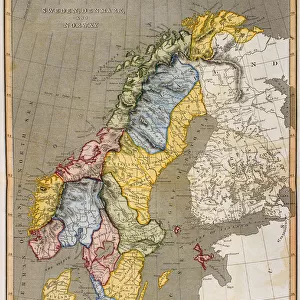
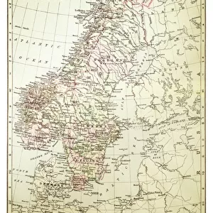
Greetings Card : Map of Sweden and Norway 1900


![]()
Cards from Fine Art Storehouse
Map of Sweden and Norway 1900
Meyers hand-Atlas Leipzig und Wien Verlag des Bibliographischen Instituts 1900
Unleash your creativity and transform your space into a visual masterpiece!
THEPALMER
Media ID 18106941
© 2014 Roberto Adrian Photography
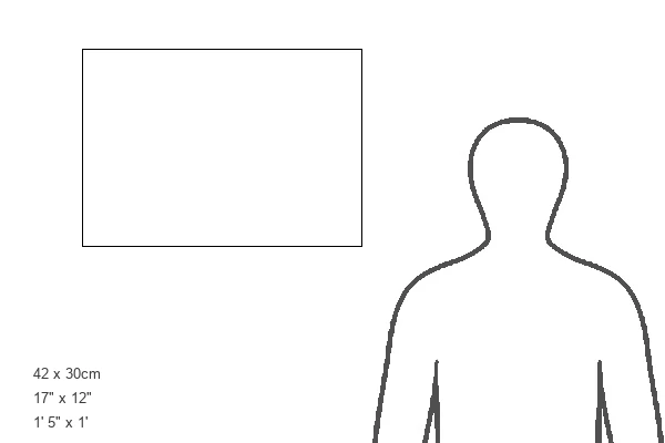
Greetings Card Large (A4)
Add a touch of history and culture to your greetings with our exquisite Map of Sweden and Norway 1900 card from Media Storehouse's Fine Art Greetings Cards collection. This beautifully detailed map, taken from THEPALMER's publication in the renowned Meyers Hand-Atlas, showcases the intricate borders and topography of Sweden and Norway as they appeared in 1900. Perfect for the history buff or travel enthusiast in your life, this unique and captivating card is sure to make any occasion a memorable one.
Create your own large greetings card. Size when folded is A4 (21x30cm or 8.3x11.7 inches)
Greetings Cards suitable for Birthdays, Weddings, Anniversaries, Graduations, Thank You and much more
Estimated Image Size (if not cropped) is 21cm x 29.7cm (8.3" x 11.7")
Estimated Product Size is 42cm x 29.7cm (16.5" x 11.7")
These are individually made so all sizes are approximate
Artwork printed orientated as per the preview above, with portrait (vertical) orientation to match the source image.
FEATURES IN THESE COLLECTIONS
> Fine Art Storehouse
> Map
> Historical Maps
> Europe
> Norway
> Related Images
> Europe
> Sweden
> Related Images
EDITORS COMMENTS
In this print titled "Map of Sweden and Norway 1900" we are transported back in time to the turn of the 20th century. The meticulous detail and artistry captured by THEPALMER, a skilled photographer from Fine Art Storehouse, allows us to explore the historical geography of these Scandinavian countries. The map itself is a reproduction from Meyers hand-Atlas Leipzig und Wien Verlag des Bibliographischen Instituts 1900 - an esteemed publication renowned for its accuracy and cartographic excellence. It showcases the intricate network of rivers, lakes, mountains, and cities that define both Sweden and Norway during this era. As we delve into the image, our eyes are drawn to the delicate lines that delineate borders between regions. We can trace our fingers along fjords stretching deep into Norwegian coastlines while marveling at Sweden's vast archipelagos scattered across its eastern shores. This vintage map not only serves as a visual representation but also offers glimpses into historical narratives. It invites us to ponder how transportation routes have evolved over time or how political boundaries may have shifted since then. Whether you're an avid history enthusiast or simply appreciate fine craftsmanship, this print beautifully combines artistic composition with educational value. Displayed on your wall or within your personal collection, it will undoubtedly spark conversations about Scandinavia's rich heritage while adding a touch of timeless elegance to any space.
MADE IN THE UK
Safe Shipping with 30 Day Money Back Guarantee
FREE PERSONALISATION*
We are proud to offer a range of customisation features including Personalised Captions, Color Filters and Picture Zoom Tools
SECURE PAYMENTS
We happily accept a wide range of payment options so you can pay for the things you need in the way that is most convenient for you
* Options may vary by product and licensing agreement. Zoomed Pictures can be adjusted in the Basket.