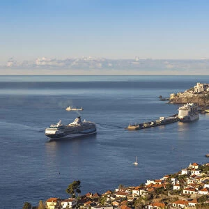
Greetings Card > North America > United States of America > New York > New York > Maps
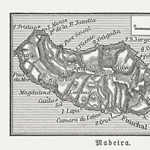
Greetings Card : Madeira island map 1883


![]()
Cards from Fine Art Storehouse
Madeira island map 1883
Encyclopedia Britannica 9th Edition New York Samuel L. Hall 1883 Vol XV
Unleash your creativity and transform your space into a visual masterpiece!
THEPALMER
Media ID 14756780
© This content is subject to copyright
Greetings Card Large (A4)
Discover the charm of yesteryears with our exquisite selection of greeting cards from the Media Storehouse. This particular card features an intriguing antique map of Madeira Island, titled "Madeira island map 1883," taken from the Encyclopedia Britannica 9th Edition New York Samuel L. Hall 1883 Vol XV. The detailed and captivating illustration by THEPALMER from the Fine Art Storehouse adds an elegant touch to your message. Whether it's for a birthday, anniversary, or just to brighten someone's day, our vintage greeting cards are sure to leave a lasting impression.
Create your own large greetings card. Size when folded is A4 (21x30cm or 8.3x11.7 inches)
Greetings Cards suitable for Birthdays, Weddings, Anniversaries, Graduations, Thank You and much more
Estimated Image Size (if not cropped) is 29.7cm x 21cm (11.7" x 8.3")
Estimated Product Size is 29.7cm x 42cm (11.7" x 16.5")
These are individually made so all sizes are approximate
Artwork printed orientated as per the preview above, with landscape (horizontal) orientation to match the source image.
FEATURES IN THESE COLLECTIONS
> Fine Art Storehouse
> Map
> Historical Maps
> Maps and Charts
> Related Images
> North America
> United States of America
> New York
> New York
> Maps
> North America
> United States of America
> New York
> Related Images
EDITORS COMMENTS
In this photo print, titled "Madeira Island Map 1883" we are transported back in time to the late 19th century. The image showcases a meticulously detailed map of Madeira Island, taken from the Encyclopedia Britannica's 9th Edition published in New York by Samuel L. Hall in 1883. The map itself is a testament to the artistry and precision of cartography during that era. Every contour line, river, and coastal feature is intricately depicted with remarkable accuracy. It offers viewers a glimpse into the geographical layout of Madeira Island as it was known over a century ago. As we study this historical artifact, our imagination takes flight as we envision explorers and adventurers using similar maps to navigate their way through uncharted territories. We can almost feel their excitement and anticipation as they set sail towards new horizons. "ThePALMER" has expertly captured this piece of history through his lens, preserving its delicate details for generations to come. The composition is visually striking with its sepia tones evoking nostalgia while enhancing the vintage aesthetic. Whether you have an affinity for cartography or simply appreciate fine art photography, this print serves as both an educational tool and a beautiful decorative piece for any space. It invites us to reflect on how far we've come while honoring the rich heritage embedded within these antique maps.
MADE IN THE UK
Safe Shipping with 30 Day Money Back Guarantee
FREE PERSONALISATION*
We are proud to offer a range of customisation features including Personalised Captions, Color Filters and Picture Zoom Tools
SECURE PAYMENTS
We happily accept a wide range of payment options so you can pay for the things you need in the way that is most convenient for you
* Options may vary by product and licensing agreement. Zoomed Pictures can be adjusted in the Basket.