Greetings Card > Europe > Austria > Maps
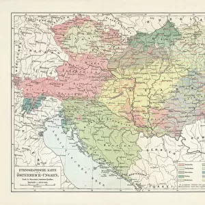
Greetings Card : Austria Hungary map 1893


![]()
Cards from Fine Art Storehouse
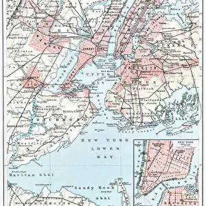
Austria Hungary map 1893
Johnsonas Universal Cyclopedia - Charles Kendall - New York 1893
Unleash your creativity and transform your space into a visual masterpiece!
THEPALMER
Media ID 14756578
© This content is subject to copyright
Austria Bavaria Hungary Serbia Bosnia
Greetings Card (A5)
Introducing the captivating Austria Hungary Map Greetings Cards from Media Storehouse's Fine Art Storehouse collection. These exquisite cards feature an intricately detailed reproduction of the "Austria Hungary Map 1893" by THEPALMER, originally published in Johnson's Universal Cyclopedia from Charles Kendall in New York. The vintage map design adds a touch of historical charm to any correspondence, making these cards perfect for birthdays, anniversaries, or just to brighten someone's day. Travel back in time and explore the rich history of Austria Hungary with every card you send.
Create your own greetings card. Size when folded is A5 (14.5x21cm or 5.7x8.3 inches)
Greetings Cards suitable for Birthdays, Weddings, Anniversaries, Graduations, Thank You and much more
Estimated Image Size (if not cropped) is 21cm x 14.5cm (8.3" x 5.7")
Estimated Product Size is 21cm x 29cm (8.3" x 11.4")
These are individually made so all sizes are approximate
Artwork printed orientated as per the preview above, with landscape (horizontal) orientation to match the source image.
FEATURES IN THESE COLLECTIONS
> Fine Art Storehouse
> Map
> Historical Maps
> Europe
> Austria
> Related Images
> Europe
> Bosnia and Herzegovina
> Maps
> Europe
> Hungary
> Related Images
> Europe
> Related Images
EDITORS COMMENTS
In this print titled "Austria Hungary map 1893" we are transported back in time to the late 19th century, where cartography was both an art and a science. This meticulously detailed map, sourced from Johnson's Universal Cyclopedia by Charles Kendall, showcases the vast territories of Austria-Hungary during that era. The rich hues and intricate lines on the print bring to life a world long gone but not forgotten. The borders of Austria, Bavaria, Bosnia, Serbia, and Hungary are clearly marked with precision and accuracy. Each region is distinguished by its own unique characteristics - from the majestic Alpine landscapes in Austria to the vibrant cultural heritage of Hungary. As we delve into this historical artifact captured by THEPALMER for Fine Art Storehouse, we can't help but marvel at how much Europe has transformed over time. It serves as a reminder of the complex geopolitical landscape that once existed within these lands. This photograph invites us to explore our collective past while appreciating the craftsmanship involved in creating such maps. It sparks curiosity about how people navigated through these territories before modern technology made it so effortless. Whether you're an avid history enthusiast or simply captivated by vintage aesthetics, this stunning print will undoubtedly transport you back in time and ignite your imagination as you ponder upon the intricacies of European history.
MADE IN THE UK
Safe Shipping with 30 Day Money Back Guarantee
FREE PERSONALISATION*
We are proud to offer a range of customisation features including Personalised Captions, Color Filters and Picture Zoom Tools
SECURE PAYMENTS
We happily accept a wide range of payment options so you can pay for the things you need in the way that is most convenient for you
* Options may vary by product and licensing agreement. Zoomed Pictures can be adjusted in the Basket.