Greetings Card > Maps and Charts > Turkey
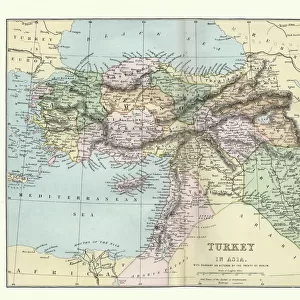
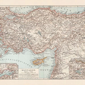
Greetings Card : Antique map of Turkey, 1897, late 19th Century


![]()
Cards from Fine Art Storehouse
Antique map of Turkey, 1897, late 19th Century
Vintage engraving of a Antique map of Turkey, 1897, late 19th Century
Unleash your creativity and transform your space into a visual masterpiece!
duncan1890
Media ID 18206103
© of Duncan P Walker
Greetings Card Large (A4)
Add a touch of history and elegance to your greetings with our Antique Map of Turkey Greetings Cards from Media Storehouse. Featuring a stunning vintage engraving of Turkey from 1897, late 19th Century, created by the talented artist duncan1890 from Fine Art Storehouse. These beautifully designed cards transport you back in time, making them a perfect gift for history enthusiasts, travelers, or anyone who appreciates the charm of vintage maps. Send a message of warmth, connection, and nostalgia with our Antique Map of Turkey Greetings Cards.
Create your own large greetings card. Size when folded is A4 (21x30cm or 8.3x11.7 inches)
Greetings Cards suitable for Birthdays, Weddings, Anniversaries, Graduations, Thank You and much more
Estimated Image Size (if not cropped) is 29.7cm x 21cm (11.7" x 8.3")
Estimated Product Size is 29.7cm x 42cm (11.7" x 16.5")
These are individually made so all sizes are approximate
Artwork printed orientated as per the preview above, with landscape (horizontal) orientation to match the source image.
FEATURES IN THESE COLLECTIONS
> Fine Art Storehouse
> Map
> Historical Maps
> Asia
> Turkey
> Related Images
> Maps and Charts
> Related Images
EDITORS COMMENTS
This print showcases an exquisite antique map of Turkey, dating back to the late 19th century. Crafted with meticulous detail and precision, this vintage engraving from 1897 offers a glimpse into the rich history and cultural heritage of this enchanting land. The map itself is a true work of art, featuring intricate illustrations of cities, rivers, mountains, and coastlines that beautifully capture the geography of Turkey during that era. The delicate lines and elegant typography evoke a sense of nostalgia for a bygone time when cartography was both scientific and artistic. As we gaze upon this remarkable piece, we are transported back in time to an era when explorers embarked on grand adventures across uncharted territories. It serves as a reminder of the importance placed on maps as tools for discovery and understanding. Duncan1890's skillful photography has expertly captured every minute detail of this antique masterpiece. From the faded colors to the aged texture, each element adds depth and character to this extraordinary print. Whether you are an avid collector or simply appreciate historical artifacts, this print will undoubtedly become a cherished addition to any space. Its timeless beauty transcends generations while offering us a window into Turkey's past – reminding us how far we have come while honoring our shared human history.
MADE IN THE UK
Safe Shipping with 30 Day Money Back Guarantee
FREE PERSONALISATION*
We are proud to offer a range of customisation features including Personalised Captions, Color Filters and Picture Zoom Tools
SECURE PAYMENTS
We happily accept a wide range of payment options so you can pay for the things you need in the way that is most convenient for you
* Options may vary by product and licensing agreement. Zoomed Pictures can be adjusted in the Basket.