Greetings Card > Europe > France > Maps
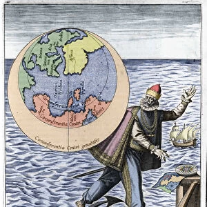
Greetings Card : Two men support the earthly gobe, with the map of South America (etching, 1717)
")
")

![]()
Cards from Fine Art Finder
Two men support the earthly gobe, with the map of South America (etching, 1717)
LRI4711169 Two men support the earthly gobe, with the map of South America (etching, 1717) by Nolin, Jean-Baptiste (c.1657-1708); Private Collection; (add.info.: Two men support the earthly gobe, with the map of South America - Engraving from the atlas le theatre du monde, 1717, by Jean Baptiste Nolin (1686-1762) - Map of South America, hold by two giants - From " Le Theatre du Monde" 1717 by Jean-Baptiste Nolin); Luisa Ricciarini; French, out of copyright
Media ID 22837420
© Luisa Ricciarini / Bridgeman Images
Atlas Book Atlas Mythology Bearer Earth Globe Form Semicircle Geographical Map Half Circle
Greetings Card Large (A4)
Discover the captivating beauty of the past with our exclusive range of greeting cards from Media Storehouse. This design features an enchanting etching by Jean-Baptiste Nolin from 1717, titled 'Two men support the earthly gobe, with the map of South America.' The intricate detail of Luisa Ricciarini's Fine Art Finder reproduction brings history to life, transporting you to another era. Perfect for those who appreciate art and history, these cards add a touch of sophistication and thoughtfulness to any occasion.
Create your own large greetings card. Size when folded is A4 (21x30cm or 8.3x11.7 inches)
Greetings Cards suitable for Birthdays, Weddings, Anniversaries, Graduations, Thank You and much more
Estimated Image Size (if not cropped) is 29.7cm x 21cm (11.7" x 8.3")
Estimated Product Size is 29.7cm x 42cm (11.7" x 16.5")
These are individually made so all sizes are approximate
Artwork printed orientated as per the preview above, with landscape (horizontal) orientation to match the source image.
FEATURES IN THESE COLLECTIONS
> Fine Art Finder
> Artists
> Frederick de Wit
> Fine Art Finder
> Artists
> Jean-Baptiste Nolin
> Maps and Charts
> Related Images
> South America
> Related Images
EDITORS COMMENTS
In this etching from 1717, we are transported to a world where mythology and geography intertwine. Two men, depicted as giants, stand proudly as they support the weight of the earthly globe upon their shoulders. The map of South America is intricately etched onto the surface of the globe, showcasing its diverse landscapes and rich history. The artist behind this remarkable piece is Jean-Baptiste Nolin, whose talent for capturing both form and detail shines through in every line. This engraving comes from his renowned atlas "Le Theatre du Monde" which was published in 1717. As we gaze at this print, we are reminded of the power that humans possess to shape our world. These mythological characters symbolize our ability to bear the weight of knowledge and understanding about our planet's geography. They serve as a reminder that it is through exploration and discovery that we expand our horizons. Luisa Ricciarini has beautifully captured this allegorical scene with her skilled reproduction technique. Through her work, she brings new life to Nolin's original masterpiece. This print serves not only as a stunning piece of art but also as a testament to humanity's curiosity and thirst for knowledge about our world. It invites us to explore South America's vast beauty while contemplating our place within it.
MADE IN THE UK
Safe Shipping with 30 Day Money Back Guarantee
FREE PERSONALISATION*
We are proud to offer a range of customisation features including Personalised Captions, Color Filters and Picture Zoom Tools
SECURE PAYMENTS
We happily accept a wide range of payment options so you can pay for the things you need in the way that is most convenient for you
* Options may vary by product and licensing agreement. Zoomed Pictures can be adjusted in the Basket.