Greetings Card > Europe > United Kingdom > England > Maps
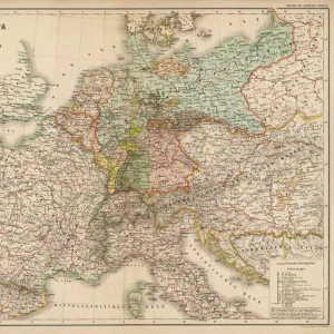
Greetings Card : General geological features of the British Isles (colour litho)
")
")


![]()
Cards from Fine Art Finder
General geological features of the British Isles (colour litho)
3648401 General geological features of the British Isles (colour litho) by English School, (20th century); Private Collection; (add.info.: General geological features of the British Isles. Illustration for The Survey Gazetteer of the British Isles, Topographical, Statistical and Commercial, Compiled from the 1901 Census and the latest Official Returns edited by J G Bartholomew (George Newnes, 1904).); © Look and Learn
Media ID 22239000
© Look and Learn / Bridgeman Images
Greetings Card (A5)
Discover the fascinating geological history of the British Isles with our exquisite range of greeting cards from Media Storehouse. Featuring captivating colour lithographs by Bridgeman Images from Fine Art Finder, these cards showcase intricate details of the general geological features of the British Isles. Each card is a stunning representation of the English School's 20th-century work, now privately held. These cards are perfect for the geology enthusiast or as a thoughtful gift for someone with a deep appreciation for the natural world. Add a personal message and send a piece of history with every greeting.
Create your own greetings card. Size when folded is A5 (14.5x21cm or 5.7x8.3 inches)
Greetings Cards suitable for Birthdays, Weddings, Anniversaries, Graduations, Thank You and much more
Estimated Image Size (if not cropped) is 14.5cm x 21cm (5.7" x 8.3")
Estimated Product Size is 29cm x 21cm (11.4" x 8.3")
These are individually made so all sizes are approximate
Artwork printed orientated as per the preview above, with portrait (vertical) orientation to match the source image.
FEATURES IN THESE COLLECTIONS
> Fine Art Finder
> Artists
> English School
> Europe
> Germany
> Related Images
> Europe
> United Kingdom
> England
> Maps
> Europe
> United Kingdom
> England
> Posters
> Europe
> United Kingdom
> Maps
> Maps and Charts
> Early Maps
> Maps and Charts
> Geological Map
> Maps and Charts
> Related Images
EDITORS COMMENTS
This print showcases the general geological features of the British Isles in stunning detail. Created by an anonymous English School artist in the 20th century, this colour lithograph is a true masterpiece that belongs to a private collection. The image was originally intended as an illustration for "The Survey Gazetteer of the British Isles" a comprehensive publication compiled from the 1901 Census and other official records. Edited by J. G. Bartholomew and published by George Newnes in 1904, this gazetteer aimed to provide topographical, statistical, and commercial information about Britain. With its intricate depiction of various geological formations across England, Scotland, Wales, and Ireland, this print offers viewers a unique insight into the diverse landscapes that make up the British Isles. From rolling hills to rugged coastlines and everything in between, it captures both the beauty and complexity of nature's creations. As we admire this piece of artistry from Bridgeman Images' Fine Art Finder collection, let us appreciate not only its aesthetic appeal but also its historical significance. It serves as a reminder of our rich geological heritage while showcasing how humans have interacted with these landscapes over time.
MADE IN THE UK
Safe Shipping with 30 Day Money Back Guarantee
FREE PERSONALISATION*
We are proud to offer a range of customisation features including Personalised Captions, Color Filters and Picture Zoom Tools
SECURE PAYMENTS
We happily accept a wide range of payment options so you can pay for the things you need in the way that is most convenient for you
* Options may vary by product and licensing agreement. Zoomed Pictures can be adjusted in the Basket.