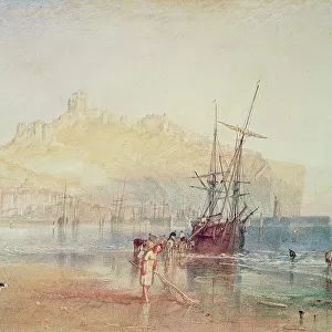
Greetings Card > Europe > United Kingdom > Wales > Pembrokeshire > Pembroke
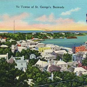
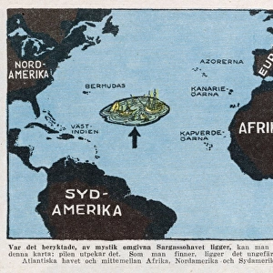
Greetings Card : Map of Bermuda (colour engraving)
")


")


![]()
Cards from Fine Art Finder
Map of Bermuda (colour engraving)
XCF285171 Map of Bermuda (colour engraving) by English School; Private Collection; English, out of copyright
Media ID 12797305
© www.bridgemanart.com
1622 Caribbean Cartouche Devonshire Geographic Hamilton Investment Mapping Pembroke Smith Southampton Tobacco Virginia Warwick Bermudas English Colony Pagets Sandys Somers
Greetings Card (A5)
Introducing the exquisite range of Bermuda Greeting Cards from Media Storehouse. Each card features a stunning, colorful engraving of "Map of Bermuda" by the English School. This beautiful work of art, sourced from Bridgeman Art and out of copyright, showcases the intricate details and rich history of Bermuda. Perfect for any occasion, these cards are a thoughtful and unique way to express your sentiments while sharing the beauty of Bermuda's heritage. Add a touch of elegance and charm to your correspondence with these captivating, art-inspired greeting cards.
Create your own greetings card. Size when folded is A5 (14.5x21cm or 5.7x8.3 inches)
Greetings Cards suitable for Birthdays, Weddings, Anniversaries, Graduations, Thank You and much more
Estimated Image Size (if not cropped) is 21cm x 14.5cm (8.3" x 5.7")
Estimated Product Size is 21cm x 29cm (8.3" x 11.4")
These are individually made so all sizes are approximate
Artwork printed orientated as per the preview above, with landscape (horizontal) orientation to match the source image.
FEATURES IN THESE COLLECTIONS
> Fine Art Finder
> Artists
> E
> English School English School
> Europe
> United Kingdom
> Scotland
> Strathclyde
> Hamilton
> Europe
> United Kingdom
> Wales
> Pembrokeshire
> Pembroke
> Maps and Charts
> Related Images
> North America
> Bermuda
> Hamilton
> North America
> Bermuda
> Maps
> North America
> Bermuda
> Related Images
EDITORS COMMENTS
This vibrant and detailed print showcases a captivating "Map of Bermuda (colour engraving)" by an English School artist. The map, dating back to the 17th century, offers a fascinating glimpse into the island's rich history and geography. The Map of Bermuda depicts the archipelago known as the Somer Islands or Bermudas, situated in the Caribbean Sea. It highlights various significant locations such as Southampton Harbour and Virginia, emphasizing their importance during that era. Created by Richard Norwood between 1590-1675, this particular version is believed to have been owned by the adventurers who invested in Bermuda's development. Divided into eight tribes including Hamilton, Smith, Devonshire, Pembroke, Pagets, Warwick, Southampton, and Sandys - each named after prominent figures - it reflects early settlement patterns on the island. Engraved with meticulous precision by Abraham Goos in 1626 – not to be confused with any commercial use – this map also features a beautifully crafted cartouche that adds elegance to its overall design. With its intricate details and historical significance encompassing both cartography and geographic exploration of Bermuda at that time period; this print serves as a valuable piece for art enthusiasts seeking glimpses into past civilizations.
MADE IN THE UK
Safe Shipping with 30 Day Money Back Guarantee
FREE PERSONALISATION*
We are proud to offer a range of customisation features including Personalised Captions, Color Filters and Picture Zoom Tools
SECURE PAYMENTS
We happily accept a wide range of payment options so you can pay for the things you need in the way that is most convenient for you
* Options may vary by product and licensing agreement. Zoomed Pictures can be adjusted in the Basket.