Greetings Card > Fine Art Finder > Artists > Augustus Butler
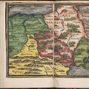
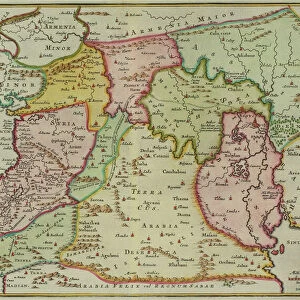
Greetings Card : Panoramic view of the Sea of Azof showing the Allied position, from government charts


![]()
Cards from Fine Art Finder
Panoramic view of the Sea of Azof showing the Allied position, from government charts
XND76038 Panoramic view of the Sea of Azof showing the Allied position, from government charts and plans and from sketches made by a military engineer, pub. by Stannard and Dixon, 1855 (litho) by Butler, Augustus (fl.1854); Private Collection; English, out of copyright
Media ID 12936608
© www.bridgemanart.com
Black Sea Crimea Kerch Kertch Peninsula Yenikale
Greetings Card (A5)
Breathtaking Panoramic Greetings Card from Media Storehouse: Witness the grandeur of the Sea of Azov with this exquisite greetings card from Media Storehouse. Featuring a panoramic view of the Sea of Azov from government charts by Bridgeman Art, this card showcases the Allied position in intricate detail. A military engineer's sketches add authenticity to this historical masterpiece, making it a unique and thoughtful gift for history enthusiasts or anyone who appreciates the beauty of the natural world. Impress with this fine art find from Fine Art Finder.
Create your own greetings card. Size when folded is A5 (14.5x21cm or 5.7x8.3 inches)
Greetings Cards suitable for Birthdays, Weddings, Anniversaries, Graduations, Thank You and much more
Estimated Image Size (if not cropped) is 21cm x 14.5cm (8.3" x 5.7")
Estimated Product Size is 21cm x 29cm (8.3" x 11.4")
These are individually made so all sizes are approximate
Artwork printed orientated as per the preview above, with landscape (horizontal) orientation to match the source image.
FEATURES IN THESE COLLECTIONS
> Fine Art Finder
> Artists
> Augustus Butler
> Fine Art Finder
> Maps (celestial & Terrestrial)
EDITORS COMMENTS
This panoramic view of the Sea of Azof transports us back to a significant moment in history. Taken from government charts and plans, as well as sketches by a military engineer, this print provides a unique glimpse into the Allied position during the Crimean War. Published in 1855 by Stannard and Dixon, it showcases the exceptional lithographic skills of Augustus Butler. The vastness of the sea stretches out before our eyes, its azure waters meeting the horizon with an air of tranquility. The strategically important locations of Kertch, Yenikale, Arabat Peninsula are marked on this map-like image, reminding us of their significance during this conflict. As we study this artwork closely, we can almost feel ourselves being transported to that era. We imagine soldiers standing guard along these shores, their presence felt but barely visible against nature's grandeur. The Black Sea looms beyond - mysterious and foreboding - serving as both a barrier and gateway for those involved in battle. This print serves as a testament to human ingenuity and determination during times of war. It reminds us that even amidst chaos and destruction, there is still beauty to be found in artistry and craftsmanship. Displayed proudly within a private collection today, this piece allows us to reflect upon history while appreciating its artistic merits. Let it serve as a reminder that art has the power not only to capture moments frozen in time but also to evoke emotions long after they have passed.
MADE IN THE UK
Safe Shipping with 30 Day Money Back Guarantee
FREE PERSONALISATION*
We are proud to offer a range of customisation features including Personalised Captions, Color Filters and Picture Zoom Tools
SECURE PAYMENTS
We happily accept a wide range of payment options so you can pay for the things you need in the way that is most convenient for you
* Options may vary by product and licensing agreement. Zoomed Pictures can be adjusted in the Basket.