Home > Arts > Artists > O > Abraham Ortelius
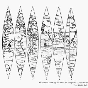
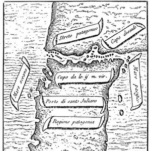
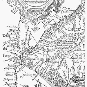
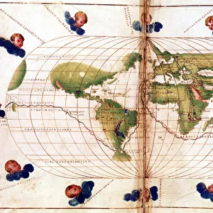
PACIFIC OCEAN MAP, 1589. Abraham Ortelius map of the Pacific Ocean

![]()
Wall Art and Photo Gifts from Granger
PACIFIC OCEAN MAP, 1589. Abraham Ortelius map of the Pacific Ocean
PACIFIC OCEAN MAP, 1589. Abraham Ortelius map of the Pacific Ocean, 1589, showing Ferdinand Magellans ship " Victoria" sailing westward on the first voyage around the world
Granger holds millions of images spanning more than 25,000 years of world history, from before the Stone Age to the dawn of the Space Age
Media ID 6617207
1589 Abraham Magellan Ortelius Pacific Ocean South Pacific Victoria
FEATURES IN THESE COLLECTIONS
> Arts
> Artists
> O
> Abraham Ortelius
> Granger Art on Demand
> Maps
> Maps and Charts
> Abraham Ortelius
> Maps and Charts
> World
EDITORS COMMENTS
This print showcases the Pacific Ocean Map from 1589, created by Abraham Ortelius. The map depicts Ferdinand Magellan's historic voyage around the world on his ship named "Victoria". As one gazes at this artwork, they are transported back in time to witness the first-ever circumnavigation of our planet. The intricate details and vibrant colors of this map bring to life the vastness and beauty of the Pacific Ocean. It is a testament to Ortelius' skill as a cartographer, capturing both geographical accuracy and artistic flair. The viewer can almost feel themselves sailing alongside Magellan, experiencing the awe-inspiring expanse of water stretching out before them. Magellan's ship, "Victoria" takes center stage in this print as it sails westward across the South Pacific. This vessel symbolizes human curiosity and determination to explore uncharted territories. It serves as a reminder that even in an era without modern technology or navigation tools, brave individuals like Magellan pushed boundaries and expanded our understanding of the world. As we admire this historical masterpiece captured by The Granger Collection, we are reminded of humanity's relentless pursuit for knowledge and discovery. This photograph print not only celebrates Ortelius' remarkable craftsmanship but also pays homage to all those who have embarked on daring maritime adventures throughout history.
MADE IN THE UK
Safe Shipping with 30 Day Money Back Guarantee
FREE PERSONALISATION*
We are proud to offer a range of customisation features including Personalised Captions, Color Filters and Picture Zoom Tools
SECURE PAYMENTS
We happily accept a wide range of payment options so you can pay for the things you need in the way that is most convenient for you
* Options may vary by product and licensing agreement. Zoomed Pictures can be adjusted in the Basket.