Home > Europe > United Kingdom > England > Maps
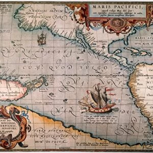
STRAITS OF MAGELLAN, 1598. The Straits of Magellan as reproduced in John Wolfes Linschoten

![]()
Wall Art and Photo Gifts from Granger
STRAITS OF MAGELLAN, 1598. The Straits of Magellan as reproduced in John Wolfes Linschoten
STRAITS OF MAGELLAN, 1598.
The Straits of Magellan as reproduced in John Wolfes Linschoten, published 1598, London, England
Granger holds millions of images spanning more than 25,000 years of world history, from before the Stone Age to the dawn of the Space Age
Media ID 12321062
1598 Age Of Discovery Cartouche Chile Ferdinand Magellan New World Portuguese South American Wolfe Linschoten Magellan Strait
FEATURES IN THESE COLLECTIONS
> Arts
> Landscape paintings
> Waterfall and river artworks
> River artworks
> Europe
> United Kingdom
> England
> London
> Related Images
> Europe
> United Kingdom
> England
> Maps
> Europe
> United Kingdom
> England
> Rivers
> Granger Art on Demand
> Maps
> Maps and Charts
> World
> South America
> Chile
> Maps
EDITORS COMMENTS
This print takes us back in time to the late 16th century, during the Age of Discovery. The image showcases a reproduction of the Straits of Magellan as depicted in John Wolfe's Linschoten, a renowned book published in 1598 in London, England. The intricate details and artistry displayed on this map transport us to an era when exploration and adventure were at their peak. The Straits of Magellan, named after Ferdinand Magellan himself, served as a crucial passage connecting the Atlantic and Pacific Oceans. This strategic waterway played a significant role in opening up new trade routes between Europe and Asia. As we delve into this visual masterpiece, we are drawn to its cartouche - an ornate decorative frame surrounding important geographical information. It serves as a testament to the Renaissance period's love for elegance and sophistication. The map also highlights various rivers flowing through South America's vast landscape, emphasizing its rich natural resources waiting to be discovered by intrepid explorers. With Portuguese influence evident throughout this representation of the New World, it reminds us of how different nations vied for dominance over these uncharted territories during that time. Overall, this print is not only visually stunning but also offers valuable insights into history and geography. It allows us to appreciate the remarkable achievements made during one of humanity's most exciting eras - an age defined by curiosity-driven expeditions that forever shaped our understanding of the world around us.
MADE IN THE UK
Safe Shipping with 30 Day Money Back Guarantee
FREE PERSONALISATION*
We are proud to offer a range of customisation features including Personalised Captions, Color Filters and Picture Zoom Tools
SECURE PAYMENTS
We happily accept a wide range of payment options so you can pay for the things you need in the way that is most convenient for you
* Options may vary by product and licensing agreement. Zoomed Pictures can be adjusted in the Basket.