Glass Place Mat > Europe > United Kingdom > England > Sussex > Ashurst Wood
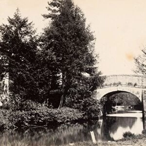
Glass Place Mat : Ashurst Tithe Map, 1844


![]()
Home Decor from West Sussex County Council
Ashurst Tithe Map, 1844
By John Wood, Lindfield. 26.6 in. to 1 m. Original size 95in × 70in
Tithe Award Map Collection
West Sussex Record Office Ref No: TD/W7
West Sussex County Council Record Office contains a fascinating history of the county of West Sussex, England
Media ID 7914407
© West Sussex County Council - All Rights Reserved
Glass Place Mat (Set of 4)
Set of 4 Glass Place Mats. Stylish and elegant polished safety glass, toughened and heat resistant (275x225mm, 7mm thick). Matching Coasters also available.
Set of 4 Glass Place Mats. Elegant polished safety glass and heat resistant. Matching Coasters may also be available
Estimated Image Size (if not cropped) is 19.1cm x 25.4cm (7.5" x 10")
Estimated Product Size is 22.5cm x 27.5cm (8.9" x 10.8")
These are individually made so all sizes are approximate
FEATURES IN THESE COLLECTIONS
> Arts
> Artists
> W
> John Wood
> Europe
> United Kingdom
> England
> Sussex
> Ashurst Wood
> Europe
> United Kingdom
> England
> Sussex
> Ashurst
> Europe
> United Kingdom
> England
> Sussex
> Lindfield
> Europe
> United Kingdom
> England
> Sussex
> Related Images
> Europe
> United Kingdom
> England
> West Sussex
> Related Images
> Maps and Charts
> Early Maps
> Maps and Charts
> Related Images
> West Sussex County Council
> West Sussex Record Office
> Tithe Award Maps, 1808-1859
EDITORS COMMENTS
This print showcases the Ashurst Tithe Map, a remarkable piece of historical mapping created by John Wood in 1844. Measuring an impressive 95 inches by 70 inches, this map offers a fascinating glimpse into the past. The meticulous attention to detail is evident as every inch of land is meticulously documented and labeled. The Ashurst Tithe Map holds great significance as it was used to determine the amount of tithes payable on each plot of land within the parish. This information would have been crucial for local farmers and landowners during that time period. Preserved within the West Sussex Record Office, this particular print serves as a valuable resource for researchers and history enthusiasts alike. John Wood's expertise shines through in his cartographic skills, capturing not only geographical features but also providing insights into property boundaries and ownerships. As we delve into this snapshot from the past, we are transported back to an era where agriculture played a vital role in shaping communities. It is important to note that this print should not be used for commercial purposes; rather, it serves as a testament to our rich heritage and provides an opportunity for us to appreciate the craftsmanship involved in creating such intricate maps. Thanks to West Sussex County Council's dedication towards preserving historical artifacts like these, future generations can continue exploring our collective history with awe and reverence.
MADE IN THE UK
Safe Shipping with 30 Day Money Back Guarantee
FREE PERSONALISATION*
We are proud to offer a range of customisation features including Personalised Captions, Color Filters and Picture Zoom Tools
SECURE PAYMENTS
We happily accept a wide range of payment options so you can pay for the things you need in the way that is most convenient for you
* Options may vary by product and licensing agreement. Zoomed Pictures can be adjusted in the Basket.