Glass Place Mat > Africa > Egypt > Maps
Glass Place Mat : PANC2A-00003


![]()
Home Decor from North Wind
PANC2A-00003
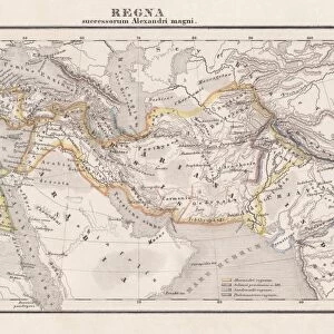
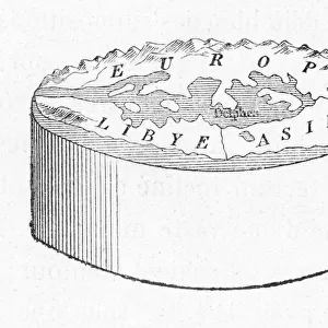
Map of the empire of Alexander the Great in 323 BC.
Printed color lithograph of a 19th-century illustration
North Wind Picture Archives brings history to life with stock images and hand-colored illustrations
Media ID 5878344
© North Wind Picture Archives
300s Bc 4th Century Bc Alexander Iii Alexander Of Macedon Alexander The Great Ancient Egypt Ancient Greece Ancient Greek Ancient History Asia Minor Babylon Babylonia Classical Civilization Egypt Europe European Greece Greek India Macedonian Mediterranean Sea Mesopotamia Mid East Middle East Persia Syria Aristotle Bactria Black Sea Caspian Sea Macedon Macedonia Parthia Persian Gulf Red Sea
Glass Place Mat (Set of 4)
Set of 4 Glass Place Mats. Stylish and elegant polished safety glass, toughened and heat resistant (275x225mm, 7mm thick). Matching Coasters also available.
Set of 4 Glass Place Mats. Elegant polished safety glass and heat resistant. Matching Coasters may also be available
Estimated Image Size (if not cropped) is 25.4cm x 15.8cm (10" x 6.2")
Estimated Product Size is 27.5cm x 22.5cm (10.8" x 8.9")
These are individually made so all sizes are approximate
FEATURES IN THESE COLLECTIONS
> Africa
> Egypt
> Related Images
> Arts
> Artists
> S
> Syrian Syrian
> Asia
> India
> Related Images
> Asia
> Related Images
> Asia
> Syria
> Related Images
> Maps and Charts
> Early Maps
> North Wind Picture Archives
> Ancient history
> North Wind Picture Archives
> Maps
EDITORS COMMENTS
This stunning vintage print showcases a detailed map of the vast empire of Alexander the Great in 323 BC. The intricately designed lithograph, created in the 19th century, beautifully captures the grandeur and extent of this historic empire. The map highlights various regions including Europe, Egypt, Greece, India, Syria, Persia, Mesopotamia, Parthia, Babylonia and more. It offers a glimpse into the expansive territories conquered by Alexander III of Macedon during his reign as one of history's greatest military leaders. With its vibrant printed colors and meticulous illustration style reminiscent of classical civilization artwork, this print is not only an informative historical document but also a piece of art that transports us back to ancient times. As we explore this image further, we can trace Alexander's conquests across land and sea – from Macedonia to Asia Minor and Bactria; from the Mediterranean Sea to the Black Sea; from the Caspian Sea to the Persian Gulf. This visual representation allows us to appreciate both the scale and significance of his achievements. Whether you are an enthusiast for ancient history or simply captivated by beautiful illustrations depicting past civilizations' glory days - this remarkable print is sure to be a fascinating addition to any collection.
MADE IN THE UK
Safe Shipping with 30 Day Money Back Guarantee
FREE PERSONALISATION*
We are proud to offer a range of customisation features including Personalised Captions, Color Filters and Picture Zoom Tools
SECURE PAYMENTS
We happily accept a wide range of payment options so you can pay for the things you need in the way that is most convenient for you
* Options may vary by product and licensing agreement. Zoomed Pictures can be adjusted in the Basket.