Glass Place Mat > Animals > Mammals > Muridae > Western Mouse
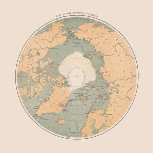
Glass Place Mat : Map of the Arctic (coloured engraving)
")
")


![]()
Home Decor from Fine Art Finder
Map of the Arctic (coloured engraving)
6014052 Map of the Arctic (coloured engraving) by American School, (19th century); Private Collection; (add.info.: Map of the Arctic. Illustration from Crams Unrivalled Atlas of the World (Edward Williamson, Kansas City, Missouri, 1887).); © Look and Learn
Media ID 23277428
© Look and Learn / Bridgeman Images
Arctic Danish Danmark Denmark Greenland North Pole Polar Canadians
Glass Place Mat (Set of 4)
Set of 4 Glass Place Mats. Stylish and elegant polished safety glass, toughened and heat resistant (275x225mm, 7mm thick). Matching Coasters also available.
Set of 4 Glass Place Mats. Elegant polished safety glass and heat resistant. Matching Coasters may also be available
Estimated Image Size (if not cropped) is 20cm x 25.4cm (7.9" x 10")
Estimated Product Size is 22.5cm x 27.5cm (8.9" x 10.8")
These are individually made so all sizes are approximate
FEATURES IN THESE COLLECTIONS
> Fine Art Finder
> Artists
> American School
> Fine Art Finder
> Artists
> English School
> Animals
> Mammals
> Muridae
> Western Mouse
> Arts
> Artists
> O
> Oceanic Oceanic
> Asia
> Related Images
> Europe
> Denmark
> Related Images
> Europe
> Russia
> Related Images
EDITORS COMMENTS
This coloured engraving, titled "Map of the Arctic" takes us back to the late 19th century when exploration and discovery were at their peak. The intricate details and vibrant colors bring this historical map to life, showcasing the vastness of the Arctic region. The map encompasses various countries and territories, including Canada, Greenland (part of Denmark), Europe, Scandinavia, Russia, and Asia. It serves as a testament to the global interest in this remote area during that time. The North Pole stands proudly at its center, symbolizing mankind's fascination with conquering new frontiers. As we delve into this print from a private collection, we are reminded of Crams Unrivalled Atlas of the World by Edward Williamson—a renowned cartographer based in Kansas City—who published this masterpiece in 1887. This visual representation not only aids geographical understanding but also highlights the importance of oceanic navigation for explorers venturing into uncharted waters. The presence of Canadian and Danish flags on the map signifies their involvement in Arctic expeditions while emphasizing their respective roles as key players in shaping our understanding of this mysterious region. Additionally, it reminds us that exploration is an integral part of human history—driven by curiosity and a desire to expand knowledge beyond known boundaries. Through Bridgeman Images' reproduction efforts, we can now appreciate this remarkable piece as if transported back to an era where polar exploration was both dangerous and awe-inspiring.
MADE IN THE UK
Safe Shipping with 30 Day Money Back Guarantee
FREE PERSONALISATION*
We are proud to offer a range of customisation features including Personalised Captions, Color Filters and Picture Zoom Tools
SECURE PAYMENTS
We happily accept a wide range of payment options so you can pay for the things you need in the way that is most convenient for you
* Options may vary by product and licensing agreement. Zoomed Pictures can be adjusted in the Basket.