Glass Frame > North America > Mexico > Maps
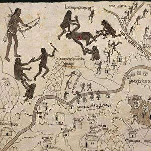
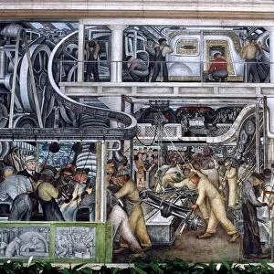
Glass Frame : Map of Nueva Galicia, historic territory of Mexico, 1550


![]()
Mounted Prints from Universal Images Group (UIG)
Map of Nueva Galicia, historic territory of Mexico, 1550
Cartography, Mexico, 16th century. Map of Nueva Galicia, historic territory of Mexico, 1550
Universal Images Group (UIG) manages distribution for many leading specialist agencies worldwide
Media ID 9570921
© DEA / G. DAGLI ORTI
16th Century Killing Large Group Of People Mexico North American Tribal Culture Religious Offering Sacrifice Traditional Culture Western Script
7"x5" Glass Mount
Wall mounted or free-standing, these black edged glass frames feature a smooth chamfered edge and a stylish black border (on back face of the glass). Manufactured from 4mm thick glass, Glass Mounts are a durable, professional way of displaying and protecting your prints. Your 7x5 print is slotted into the back of the frame so can easily be changed if needed.
Tempered Glass Mounts are ideal for wall display, plus the smaller sizes can also be used free-standing via an integral stand
Estimated Image Size (if not cropped) is 17.7cm x 12.7cm (7" x 5")
Estimated Product Size is 20.3cm x 16.2cm (8" x 6.4")
These are individually made so all sizes are approximate
Artwork printed orientated as per the preview above, with landscape (horizontal) orientation to match the source image.
FEATURES IN THESE COLLECTIONS
> Maps and Charts
> Related Images
> North America
> Mexico
> Maps
> North America
> Mexico
> Related Images
> North America
> Related Images
> Universal Images Group (UIG)
> Art
> Painting, Sculpture & Prints
> Cartography
EDITORS COMMENTS
This print showcases a historic treasure from the 16th century - a detailed map of Nueva Galicia, an important territory in Mexico during that time. The map, created through cartography techniques, offers a glimpse into the past and provides valuable insights into the region's geography and landmarks. The image captures the essence of this historical period with its full-length depiction. In the foreground stands a traditional hut, symbolizing the indigenous culture prevalent in Nueva Galicia at that time. The studio shot highlights every intricate detail of this remarkable piece of art and craft. The map also sheds light on religious practices and beliefs as it features illustrations depicting sacrifices and killings associated with ancient Mexican religion. This serves as a reminder of how deeply rooted religion was in shaping society during that era. With its horizontal layout, viewers can appreciate the building exteriors depicted on this large-scale map. It is fascinating to observe how North American tribal culture influenced Western script within this artwork. While no people are present in this particular photograph, one cannot help but imagine the bustling activity that would have surrounded such maps back then. They were not only functional tools for navigation but also served as religious offerings or objects used for cultural ceremonies. Overall, this print takes us on a journey through time by showcasing an extraordinary artifact representing Mexico's rich history and traditional culture.
MADE IN THE UK
Safe Shipping with 30 Day Money Back Guarantee
FREE PERSONALISATION*
We are proud to offer a range of customisation features including Personalised Captions, Color Filters and Picture Zoom Tools
SECURE PAYMENTS
We happily accept a wide range of payment options so you can pay for the things you need in the way that is most convenient for you
* Options may vary by product and licensing agreement. Zoomed Pictures can be adjusted in the Basket.