Glass Frame > Europe > United Kingdom > England > London > Museums > National Army Museum
Glass Frame : WW2 Poster -- Map of the British Army


![]()
Mounted Prints from Mary Evans Picture Library
WW2 Poster -- Map of the British Army
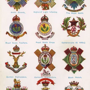
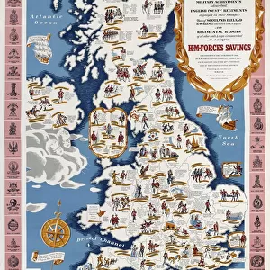
A Map of the British Army with Battle Honours, Military Achievements and Regimental Badges, first published in 1944 by HM Forces Savings Committee. Colour photolithograph, artist unknown, reproduction published by HMSO, London, 1952. Date: 1944
Mary Evans Picture Library makes available wonderful images created for people to enjoy over the centuries
Media ID 14160303
© The National Army Museum / Mary Evans Picture Library
1944 Achievements Badges Committee Counties Forces Hmso Honours Isles Maps Photolithograph Regiment Regimental Regiments Savings
7"x5" Glass Mount
Wall mounted or free-standing, these black edged glass frames feature a smooth chamfered edge and a stylish black border (on back face of the glass). Manufactured from 4mm thick glass, Glass Mounts are a durable, professional way of displaying and protecting your prints. Your 7x5 print is slotted into the back of the frame so can easily be changed if needed.
Tempered Glass Mounts are ideal for wall display, plus the smaller sizes can also be used free-standing via an integral stand
Estimated Image Size (if not cropped) is 12.7cm x 17.1cm (5" x 6.7")
Estimated Product Size is 16.2cm x 20.3cm (6.4" x 8")
These are individually made so all sizes are approximate
Artwork printed orientated as per the preview above, with portrait (vertical) orientation to match the source image.
FEATURES IN THESE COLLECTIONS
> Animals
> Mammals
> Muridae
> Fortior
> Arts
> Artists
> Related Images
> Europe
> United Kingdom
> England
> London
> Museums
> British Library
> Europe
> United Kingdom
> England
> London
> Museums
> British Museum
> Europe
> United Kingdom
> England
> London
> Museums
> National Army Museum
> Europe
> United Kingdom
> England
> London
> Sights
> British Museum
> Europe
> United Kingdom
> Maps
> Historic
> Battles
> Related Images
> Maps and Charts
> Early Maps
> Maps and Charts
> Popular Maps
> Maps and Charts
> Related Images
EDITORS COMMENTS
This WW2 poster features a detailed and vibrant map of the British Army, first published in 1944 by the HM Forces Savings Committee. The map highlights the Battle Honours, Military Achievements, and Regimental Badges of various regiments and counties within the British Army during the Second World War. The map covers the British Isles and parts of Europe, showcasing the strategic locations of significant military engagements and battles fought by the British forces during the forties. The richly colored photolithograph, created by an unknown artist, brings history to life with intricate details and accurate representations of each regimental badge. Published by HMSO (Her Majesty's Stationery Office) in London in 1952, this map serves as a testament to the bravery and resilience of the British military during the 1940s. It is a remarkable piece of WW2 history, providing a visual representation of the various regiments and their achievements throughout the war. The map's intricate design showcases the diversity and unity of the British Army, with each regiment's badge represented in its unique and distinctive form. This poster is not only a valuable historical document but also an aesthetically pleasing piece of art that captures the spirit of the British military during the Second World War.
MADE IN THE UK
Safe Shipping with 30 Day Money Back Guarantee
FREE PERSONALISATION*
We are proud to offer a range of customisation features including Personalised Captions, Color Filters and Picture Zoom Tools
SECURE PAYMENTS
We happily accept a wide range of payment options so you can pay for the things you need in the way that is most convenient for you
* Options may vary by product and licensing agreement. Zoomed Pictures can be adjusted in the Basket.