Glass Frame > Europe > United Kingdom > England > London > Boroughs > City of Westminster
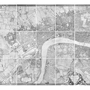
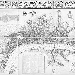
Glass Frame : Map of Westminster, 1593


![]()
Mounted Prints from Mary Evans Picture Library
Map of Westminster, 1593
Map of Westminster, London, 1593
Mary Evans Picture Library makes available wonderful images created for people to enjoy over the centuries
Media ID 570810
© Mary Evans Picture Library 2015 - https://copyrighthub.org/s0/hub1/creation/maryevans/MaryEvansPictureID/10001810
7"x5" Glass Mount
Wall mounted or free-standing, these black edged glass frames feature a smooth chamfered edge and a stylish black border (on back face of the glass). Manufactured from 4mm thick glass, Glass Mounts are a durable, professional way of displaying and protecting your prints. Your 7x5 print is slotted into the back of the frame so can easily be changed if needed.
Tempered Glass Mounts are ideal for wall display, plus the smaller sizes can also be used free-standing via an integral stand
Estimated Image Size (if not cropped) is 17.7cm x 12.7cm (7" x 5")
Estimated Product Size is 20.3cm x 16.2cm (8" x 6.4")
These are individually made so all sizes are approximate
Artwork printed orientated as per the preview above, with landscape (horizontal) orientation to match the source image.
FEATURES IN THESE COLLECTIONS
> Arts
> Landscape paintings
> Waterfall and river artworks
> River artworks
> Europe
> United Kingdom
> England
> London
> Boroughs
> City of Westminster
> Europe
> United Kingdom
> England
> London
> Related Images
> Europe
> United Kingdom
> England
> London
> River Thames
> Europe
> United Kingdom
> England
> Maps
> Europe
> United Kingdom
> England
> Posters
> Europe
> United Kingdom
> England
> Related Images
> Europe
> United Kingdom
> England
> Rivers
> Europe
> United Kingdom
> England
> Westminster
> Maps and Charts
> Early Maps
EDITORS COMMENTS
This print of the "Map of Westminster, 1593" takes us back in time to the bustling streets and winding riverbanks of London in the 16th century. The intricate details and historical significance captured in this map offer a glimpse into the rich history of Westminster, showcasing its importance as a political and cultural hub during this era.
As we study the layout of the city, with its narrow alleyways, grand palaces, and iconic landmarks along the Thames River, we can't help but marvel at how much has changed over the centuries. From St. James's Palace to Westminster Abbey, each building tells a story of England's past and adds layers to our understanding of this vibrant metropolis.
The meticulous craftsmanship displayed in this map is a testament to the skill and dedication of cartographers from centuries ago. Their ability to capture every street corner and architectural detail with such precision is truly remarkable.
Whether you're a history buff or simply appreciate fine artistry, this print is sure to spark your curiosity and transport you back in time to explore the sights and sounds of Elizabethan London. It serves as a reminder that even as cities evolve and grow, their roots remain firmly planted in their storied pasts.
MADE IN THE UK
Safe Shipping with 30 Day Money Back Guarantee
FREE PERSONALISATION*
We are proud to offer a range of customisation features including Personalised Captions, Color Filters and Picture Zoom Tools
SECURE PAYMENTS
We happily accept a wide range of payment options so you can pay for the things you need in the way that is most convenient for you
* Options may vary by product and licensing agreement. Zoomed Pictures can be adjusted in the Basket.