Glass Frame > Europe > United Kingdom > England > London > Sights > New River
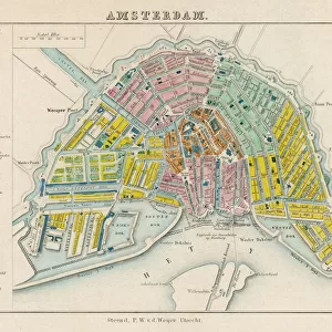
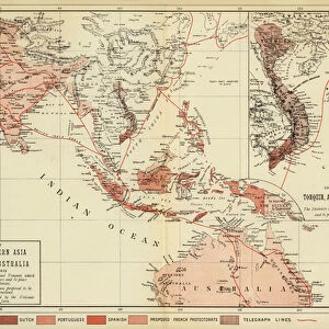
Glass Frame : Map showing Auckland & the River Waikato, New Zealand, 1863


![]()
Mounted Prints from Mary Evans Picture Library
Map showing Auckland & the River Waikato, New Zealand, 1863
Map of the country between Auckland and the River Waikato, New Zealand, illustrating the war with the native Maori tribes. Date: 1863
Mary Evans Picture Library makes available wonderful images created for people to enjoy over the centuries
Media ID 14394190
© Illustrated London News Ltd/Mary Evans
1863 Auckland Cartography Invasion May16 Natives Places Waikato Wars Zealand Manukau
7"x5" Glass Mount
Wall mounted or free-standing, these black edged glass frames feature a smooth chamfered edge and a stylish black border (on back face of the glass). Manufactured from 4mm thick glass, Glass Mounts are a durable, professional way of displaying and protecting your prints. Your 7x5 print is slotted into the back of the frame so can easily be changed if needed.
Tempered Glass Mounts are ideal for wall display, plus the smaller sizes can also be used free-standing via an integral stand
Estimated Image Size (if not cropped) is 17.7cm x 12.7cm (7" x 5")
Estimated Product Size is 20.3cm x 16.2cm (8" x 6.4")
These are individually made so all sizes are approximate
Artwork printed orientated as per the preview above, with landscape (horizontal) orientation to match the source image.
FEATURES IN THESE COLLECTIONS
> Arts
> Landscape paintings
> Waterfall and river artworks
> River artworks
> Europe
> United Kingdom
> England
> London
> Sights
> New River
> Maps and Charts
> Related Images
> Oceania
> New Zealand
> Auckland
> Oceania
> New Zealand
> Maps
> Oceania
> New Zealand
> Related Images
EDITORS COMMENTS
This intricately detailed map from 1863 provides a glimpse into the turbulent history of Auckland, New Zealand, and the surrounding region during the Maori Wars. The map, titled "Map of the Country between Auckland and the River Waikato, New Zealand," illustrates the conflict between the British colonial forces and the native Maori tribes, particularly the Waikato and Maniapoto confederations. The map highlights the strategic locations of key towns and settlements, including Auckland, Manukau Harbour, and the Waikato River. The British military encampments and fortifications are marked, as well as the Maori pa (fortified villages) and their strategic positions. The map also includes annotations indicating the movements and engagements of various military units during the conflict. The Maori Wars, which lasted from 1845 to 1872, were a series of conflicts between the British colonial forces and the Maori people over land and resources. The Waikato War, which began in 1863, was one of the most significant conflicts during this period. The British, led by Governor Thomas Gore Browne, sought to assert control over the Waikato region and its rich resources. The Maori, led by King Movement leader Rewi Maniopoto and his brother Te Kooti, resisted the British invasion, resulting in a prolonged and brutal conflict. The map offers a unique perspective on this complex and pivotal moment in New Zealand's history, providing insight into the geography, military strategy, and political dynamics of the time. The intricate cartography and annotations make it an essential resource for historians, genealogists, and anyone interested in the history of New Zealand and its people.
MADE IN THE UK
Safe Shipping with 30 Day Money Back Guarantee
FREE PERSONALISATION*
We are proud to offer a range of customisation features including Personalised Captions, Color Filters and Picture Zoom Tools
FREE COLORIZATION SERVICE
You can choose advanced AI Colorization for this picture at no extra charge!
SECURE PAYMENTS
We happily accept a wide range of payment options so you can pay for the things you need in the way that is most convenient for you
* Options may vary by product and licensing agreement. Zoomed Pictures can be adjusted in the Basket.