Glass Frame > Europe > Finland > Maps
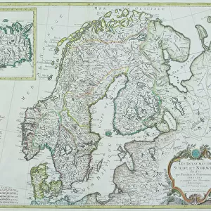
Glass Frame : Map / Scandinavia 1539


![]()
Mounted Prints from Mary Evans Picture Library
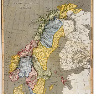
Map / Scandinavia 1539
Map of Norway, Finland, Sweden and Denmark
Mary Evans Picture Library makes available wonderful images created for people to enjoy over the centuries
Media ID 608826
© Mary Evans Picture Library 2015 - https://copyrighthub.org/s0/hub1/creation/maryevans/MaryEvansPictureID/10114108
1539 Denmark Finland Maps Norway Scandinavia Sweden
7"x5" Glass Mount
Wall mounted or free-standing, these black edged glass frames feature a smooth chamfered edge and a stylish black border (on back face of the glass). Manufactured from 4mm thick glass, Glass Mounts are a durable, professional way of displaying and protecting your prints. Your 7x5 print is slotted into the back of the frame so can easily be changed if needed.
Tempered Glass Mounts are ideal for wall display, plus the smaller sizes can also be used free-standing via an integral stand
Estimated Image Size (if not cropped) is 12.7cm x 17.7cm (5" x 7")
Estimated Product Size is 16.2cm x 20.3cm (6.4" x 8")
These are individually made so all sizes are approximate
Artwork printed orientated as per the preview above, with portrait (vertical) orientation to match the source image.
FEATURES IN THESE COLLECTIONS
> Europe
> Denmark
> Related Images
> Europe
> Finland
> Related Images
> Europe
> Norway
> Related Images
> Europe
> Related Images
EDITORS COMMENTS
This stunning print captures a piece of history with the Map of Scandinavia from 1539. The intricate details and craftsmanship of this map showcase the geographical boundaries of Norway, Finland, Sweden, and Denmark during that time period. Each country is clearly defined with its own distinct borders, giving us a glimpse into the political landscape of Europe in the 16th century.
The historical significance of this map cannot be understated as it provides valuable insight into how these countries were interconnected and how their territories were divided centuries ago. It serves as a reminder of the rich cultural heritage and complex relationships that have shaped Scandinavia over the years.
As we gaze upon this beautifully preserved piece of cartography, we are transported back in time to an era where exploration and discovery were at the forefront. The attention to detail in this map is truly remarkable, showcasing Mary Evans Picture Library's dedication to preserving historical artifacts for future generations to appreciate.
Whether you have a personal connection to Scandinavia or simply appreciate fine artistry, this Map / Scandinavia 1539 print is sure to captivate your imagination and spark curiosity about Europe's past. A true masterpiece worth admiring for its beauty and historical significance alike.
MADE IN THE UK
Safe Shipping with 30 Day Money Back Guarantee
FREE PERSONALISATION*
We are proud to offer a range of customisation features including Personalised Captions, Color Filters and Picture Zoom Tools
SECURE PAYMENTS
We happily accept a wide range of payment options so you can pay for the things you need in the way that is most convenient for you
* Options may vary by product and licensing agreement. Zoomed Pictures can be adjusted in the Basket.