Glass Frame : Map of India Shewing the Lines of Railways, Telegraphs?


![]()
Mounted Prints from Mary Evans Picture Library
Map of India Shewing the Lines of Railways, Telegraphs?
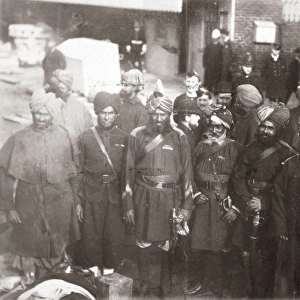
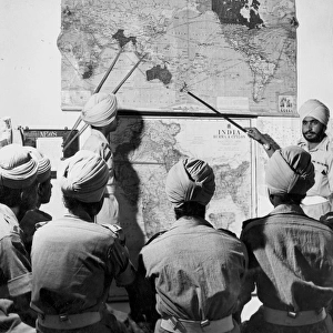
?Map of India Shewing the Lines of Railways, Telegraphs, and Dawk Routes?, specially engraved for the Indian Traveller?s Guide (nd); from papers collected by J P K Murphy, 52nd Sikhs and 9th Hodson?s Horse, after his retirement in 1924. Date: circa 1924
Mary Evans Picture Library makes available wonderful images created for people to enjoy over the centuries
Media ID 14404120
© The National Army Museum / Mary Evans Picture Library
52nd Collected Engraved Guide Hodsons Lines Murphy Papers Railways Retirement Routes Sikhs Specially Telegraphs 1924 Shewing
8"x6" Glass Mount
Wall mounted or free-standing, these black edged glass frames feature a smooth chamfered edge and a stylish black border (on back face of the glass). Manufactured from 4mm thick glass, Glass Mounts are a durable, professional way of displaying and protecting your prints. Your 8x6 print is slotted into the back of the frame so can easily be changed if needed.
Tempered Glass Mounts are ideal for wall display, plus the smaller sizes can also be used free-standing via an integral stand
Estimated Image Size (if not cropped) is 15.2cm x 20.3cm (6" x 8")
Estimated Product Size is 17.7cm x 22.8cm (7" x 9")
These are individually made so all sizes are approximate
Artwork printed orientated as per the preview above, with portrait (vertical) orientation to match the source image.
EDITORS COMMENTS
This intricately detailed map, titled 'Map of India Shewing the Lines of Railways, Telegraphs, and Dawk Routes,' offers a glimpse into the extensive communication networks of India during the early 20th century. The map, specially engraved for the Indian Traveller's Guide, was collected by J.P. K. Murphy after his retirement in 1924. The map showcases the extensive railway lines crisscrossing India, connecting major cities and towns. The telegraph lines, another crucial means of communication during this era, are depicted as thin, winding lines, connecting various parts of the country. The dawk routes, a precursor to modern postal services, are indicated by dotted lines. Murphy, a veteran of the Indian Army, served with the 52nd Sikhs and 9th Hodson's Horse. His collection of papers, including this map, provides valuable insights into the transportation and communication infrastructure of India during the British colonial period. The map's meticulous detailing and clear labeling make it an essential tool for travelers and administrators alike, highlighting the importance of effective communication and transportation networks in facilitating movement and commerce within the vast subcontinent. This map offers a fascinating glimpse into the history of India's communication systems, providing a window into the past and shedding light on the significant strides made in connecting India's diverse regions during the early 20th century.
MADE IN THE UK
Safe Shipping with 30 Day Money Back Guarantee
FREE PERSONALISATION*
We are proud to offer a range of customisation features including Personalised Captions, Color Filters and Picture Zoom Tools
SECURE PAYMENTS
We happily accept a wide range of payment options so you can pay for the things you need in the way that is most convenient for you
* Options may vary by product and licensing agreement. Zoomed Pictures can be adjusted in the Basket.