Glass Frame > Animals > Birds > Passerines > Finches > Atlantic Canary
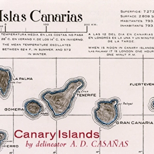
Glass Frame : Map of Hierro, Canary Islands


![]()
Mounted Prints from Mary Evans Picture Library
Map of Hierro, Canary Islands
Map of Hierro, Canary Islands. Date: circa 1908
Mary Evans Picture Library makes available wonderful images created for people to enjoy over the centuries
Media ID 14262708
© Mary Evans / Pharcide
Atlantic Canaries Canary Cruz Hierro Maps Quisisana Tenerife
7"x5" Glass Mount
Wall mounted or free-standing, these black edged glass frames feature a smooth chamfered edge and a stylish black border (on back face of the glass). Manufactured from 4mm thick glass, Glass Mounts are a durable, professional way of displaying and protecting your prints. Your 7x5 print is slotted into the back of the frame so can easily be changed if needed.
Tempered Glass Mounts are ideal for wall display, plus the smaller sizes can also be used free-standing via an integral stand
Estimated Image Size (if not cropped) is 17.7cm x 12.7cm (7" x 5")
Estimated Product Size is 20.3cm x 16.2cm (8" x 6.4")
These are individually made so all sizes are approximate
Artwork printed orientated as per the preview above, with landscape (horizontal) orientation to match the source image.
FEATURES IN THESE COLLECTIONS
> Animals
> Birds
> Passerines
> Finches
> Atlantic Canary
> Animals
> Mammals
> Cricetidae
> Santa Cruz Mouse
> Animals
> Mammals
> Muridae
> Water Mouse
> Arts
> Artists
> O
> Oceanic Oceanic
> Europe
> France
> Canton
> Landes
> Maps and Charts
> Related Images
EDITORS COMMENTS
1. Title: A Glimpse of Hierro Island in the Late 1900s: A Vintage Map Reveals the Coastal Beauty and Historical Landmarks Date: Circa 1908 Description: Step back in time with this vintage map of Hierro Island, one of the seven Canary Islands located in the Atlantic Ocean. Dating back to circa 1908, this map offers a fascinating glimpse into the geography, coastal features, and historical landmarks of this enchanting island, which has remained largely unchanged for over a century. The map, which showcases the western part of Hierro Island, reveals the intricate details of its rugged coastline, crystal-clear waters, and the winding roads that connect its quaint villages. The island's unique topography, characterized by its volcanic origins, is evident in the undulating terrain and the dramatic cliffs that plunge into the Atlantic Ocean. Some of the notable landmarks depicted on the map include the historic town of Valverde, the picturesque fishing village of El Pinar, and the iconic lighthouse of Punta Grande. The map also highlights the location of the renowned Grand Hotel Quisisana and the bustling port of Santa Cruz de la Palma, which served as the island's commercial hub during the early 1900s. As you explore this map of Hierro Island, you'll be transported back to a time when life moved at a slower pace, and the natural beauty of the island was the primary attraction for travelers. Whether you're an armchair explorer, a history buff, or simply someone who appreciates the allure of vintage maps, this stunning print is a must-have addition to your collection. Keywords: 1900s, 1908, coast, coastal, sea, Atlantic Ocean, land, water, island, islands, map, maps, Tenerife, Grand Hotel Quisisana, Santa Cruz, de, Canary, Canaries, Hierro.
MADE IN THE UK
Safe Shipping with 30 Day Money Back Guarantee
FREE PERSONALISATION*
We are proud to offer a range of customisation features including Personalised Captions, Color Filters and Picture Zoom Tools
SECURE PAYMENTS
We happily accept a wide range of payment options so you can pay for the things you need in the way that is most convenient for you
* Options may vary by product and licensing agreement. Zoomed Pictures can be adjusted in the Basket.