Glass Frame > Arts > Photorealistic artworks > Detailed art pieces > Masterful detailing in art
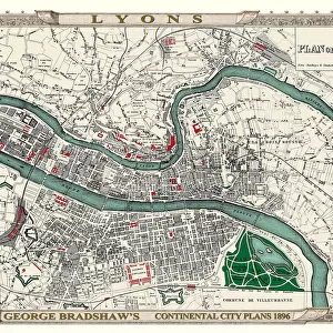
Glass Frame : Old Map of France 1852 by Henry George Collins


![]()
Mounted Prints from MapSeeker
Old Map of France 1852 by Henry George Collins
This is a finely detailed map of France remastered from a rare Atlas of the World published in 1852 by Henry George Collins. Although these Henry Collins produced maps of the highest quality in his time unfortunately not the same could be said in terms of his business success. His maps were later obtained by the famous Stanford Map Company and used in their publications
Welcome to the Mapseeker Image library and enter an historic gateway to one of the largest on-line collections of Historic Maps, Nostalgic Views, Vista's and Panorama's from a World gone by.
Media ID 20347287
© Mapseeker Publishing Ltd
Collins Collins Atlas Collins Atlas Map Collins Map
7"x5" Glass Mount
Wall mounted or free-standing, these black edged glass frames feature a smooth chamfered edge and a stylish black border (on back face of the glass). Manufactured from 4mm thick glass, Glass Mounts are a durable, professional way of displaying and protecting your prints. Your 7x5 print is slotted into the back of the frame so can easily be changed if needed.
Tempered Glass Mounts are ideal for wall display, plus the smaller sizes can also be used free-standing via an integral stand
Estimated Image Size (if not cropped) is 17.7cm x 12.7cm (7" x 5")
Estimated Product Size is 20.3cm x 16.2cm (8" x 6.4")
These are individually made so all sizes are approximate
Artwork printed orientated as per the preview above, with landscape (horizontal) orientation to match the source image.
FEATURES IN THESE COLLECTIONS
> Arts
> Photorealistic artworks
> Detailed art pieces
> Masterful detailing in art
> Maps and Charts
> Related Images
> Maps and Charts
> World
> MapSeeker
> Maps of Europe
> Maps of France PORTFOLIO
EDITORS COMMENTS
This beautifully preserved print showcases an Old Map of France from the year 1852, meticulously crafted by the talented cartographer Henry George Collins. Remastered from a rare Atlas of the World published during that era, this map offers an exquisite level of detail and accuracy that was characteristic of Collins' work. Although renowned for his exceptional craftsmanship, Henry Collins sadly did not achieve the same level of success in his business ventures. However, fate had other plans for these remarkable maps as they were later acquired by none other than the prestigious Stanford Map Company. Recognizing their value and historical significance, these maps became integral to the company's publications. Transporting us back in time, this vintage French map provides a captivating glimpse into France's geography during the mid-19th century. With its intricate borders delineating regions and departments, along with detailed topographical features such as rivers and mountains, it serves as a testament to both Collins' skillful artistry and his commitment to geographical accuracy. Whether you are a history enthusiast or simply appreciate fine cartography, this old French map is sure to captivate your imagination. Explore its faded hues and delicate lines as you trace your finger across towns long forgotten or marvel at how much has changed over centuries past. A true treasure from yesteryears brought back to life through careful preservation – behold this extraordinary piece from Henry George Collins' legacy!
MADE IN THE UK
Safe Shipping with 30 Day Money Back Guarantee
FREE PERSONALISATION*
We are proud to offer a range of customisation features including Personalised Captions, Color Filters and Picture Zoom Tools
SECURE PAYMENTS
We happily accept a wide range of payment options so you can pay for the things you need in the way that is most convenient for you
* Options may vary by product and licensing agreement. Zoomed Pictures can be adjusted in the Basket.