Glass Frame > Europe > United Kingdom > Scotland > Maps
Glass Frame : Map of the Clans and Tartans of Scotland


![]()
Mounted Prints from MapSeeker
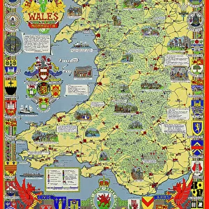
Map of the Clans and Tartans of Scotland
This map of Scotland indicates the general sphere of influence held by the clans and considerable families at the beginning of the 17th century. Some clans and families held small areas of land, and if their names are not on this map, they were not necessarily landless. The areas representing the ancient Principalities of Scotland are indicated on the map. Scotland has a rich and enduring culture steeped in history. One of the most distinctive features, of which are probably that of clanship and the predominantly Highland clans. Highland dress and the tartan is a powerful symbol of the wearerAEs pride in a Scottish ancestry and in Scotland itself. There are few, if any, other forms of national dress which can claim to make such a clear and unequivocal statement, and to be so instantly and widely recognisable
Welcome to the Mapseeker Image library and enter an historic gateway to one of the largest on-line collections of Historic Maps, Nostalgic Views, Vista's and Panorama's from a World gone by.
Media ID 20348040
8"x6" Glass Mount
Wall mounted or free-standing, these black edged glass frames feature a smooth chamfered edge and a stylish black border (on back face of the glass). Manufactured from 4mm thick glass, Glass Mounts are a durable, professional way of displaying and protecting your prints. Your 8x6 print is slotted into the back of the frame so can easily be changed if needed.
Tempered Glass Mounts are ideal for wall display, plus the smaller sizes can also be used free-standing via an integral stand
Estimated Image Size (if not cropped) is 15.2cm x 20.3cm (6" x 8")
Estimated Product Size is 17.7cm x 22.8cm (7" x 9")
These are individually made so all sizes are approximate
Artwork printed orientated as per the preview above, with portrait (vertical) orientation to match the source image.
FEATURES IN THESE COLLECTIONS
> Europe
> France
> Canton
> Landes
> Europe
> United Kingdom
> Scotland
> Maps
> Europe
> United Kingdom
> Scotland
> Posters
> Europe
> United Kingdom
> Scotland
> Related Images
> Maps and Charts
> Early Maps
> Maps and Charts
> Related Images
> MapSeeker
> Maps from the British Isles
> Scotland and Counties PORTFOLIO
EDITORS COMMENTS
This print showcases the "Map of the Clans and Tartans of Scotland" offering a glimpse into the intricate web of influence held by clans and notable families during the early 17th century. While some clans and families may not be featured on this map, it does not imply their landlessness, as they might have possessed smaller territories. The map also highlights the ancient Principalities of Scotland, providing insight into the historical divisions within this culturally rich nation. Scotland's enduring heritage is deeply rooted in its unique features such as clanship and predominantly Highland clans. Among these distinct characteristics, Highland dress and tartan stand out as powerful symbols representing pride in Scottish ancestry and love for their homeland. With its unmistakable design, tartan has become an iconic representation of Scottish identity. Few other national dresses can rival its ability to make such a clear statement or enjoy such widespread recognition across borders. This print serves as a reminder of Scotland's profound history while celebrating its cultural traditions that continue to resonate with people around the world.
MADE IN THE UK
Safe Shipping with 30 Day Money Back Guarantee
FREE PERSONALISATION*
We are proud to offer a range of customisation features including Personalised Captions, Color Filters and Picture Zoom Tools
SECURE PAYMENTS
We happily accept a wide range of payment options so you can pay for the things you need in the way that is most convenient for you
* Options may vary by product and licensing agreement. Zoomed Pictures can be adjusted in the Basket.