Glass Frame > Arts > Artists > T > John Tallis
Glass Frame : Turkey in Asia 1851


![]()
Mounted Prints from MapSeeker
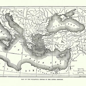
Turkey in Asia 1851
A fine facimile artworked from an antique original map of Turkey in Asia, issued as part of the 1851 edition of John Tallis and Companys " The Illustrated Atlas and Modern History of the World"
Welcome to the Mapseeker Image library and enter an historic gateway to one of the largest on-line collections of Historic Maps, Nostalgic Views, Vista's and Panorama's from a World gone by.
Media ID 20347467
© Mapseeker Publishing Ltd
John Tallis John Tallis Map Tallis Map
7"x5" Glass Mount
Wall mounted or free-standing, these black edged glass frames feature a smooth chamfered edge and a stylish black border (on back face of the glass). Manufactured from 4mm thick glass, Glass Mounts are a durable, professional way of displaying and protecting your prints. Your 7x5 print is slotted into the back of the frame so can easily be changed if needed.
Tempered Glass Mounts are ideal for wall display, plus the smaller sizes can also be used free-standing via an integral stand
Estimated Image Size (if not cropped) is 17.7cm x 12.7cm (7" x 5")
Estimated Product Size is 20.3cm x 16.2cm (8" x 6.4")
These are individually made so all sizes are approximate
Artwork printed orientated as per the preview above, with landscape (horizontal) orientation to match the source image.
FEATURES IN THESE COLLECTIONS
> Arts
> Artists
> T
> John Tallis
> Asia
> Turkey
> Related Images
> Maps and Charts
> Related Images
> Maps and Charts
> World
> MapSeeker
> Maps of Asia and Middle East
> Maps of Countries in Asia PORTFOLIO
EDITORS COMMENTS
This stunning print showcases a fine facsimile artwork of an antique original map of Turkey in Asia, dating back to 1851. The map was originally issued as part of the renowned John Tallis and Company's "The Illustrated Atlas and Modern History of the World". With intricate details and exquisite craftsmanship, this old map offers a glimpse into the historical geography of Turkey in Asia during the mid-19th century. It portrays not only the geographical features but also provides insights into political boundaries, cities, towns, rivers, and other significant landmarks. John Tallis and John Rapkin collaborated on creating this masterpiece that captures both artistic beauty and cartographic accuracy. Their dedication to detail is evident in every line drawn on this vintage Turkish map. As you gaze upon this piece, you can imagine yourself embarking on a journey through time. Transported to an era when explorers relied on maps like these for navigation or historians sought knowledge about distant lands. Whether you are a history enthusiast or simply appreciate artistry from bygone eras, this print will undoubtedly become a cherished addition to your collection. Its timeless appeal serves as a reminder of how maps have shaped our understanding of the world throughout centuries.
MADE IN THE UK
Safe Shipping with 30 Day Money Back Guarantee
FREE PERSONALISATION*
We are proud to offer a range of customisation features including Personalised Captions, Color Filters and Picture Zoom Tools
SECURE PAYMENTS
We happily accept a wide range of payment options so you can pay for the things you need in the way that is most convenient for you
* Options may vary by product and licensing agreement. Zoomed Pictures can be adjusted in the Basket.