Glass Frame > Europe > United Kingdom > England > London > Towns > Wapping
Glass Frame : Map Of London


![]()
Mounted Prints from Fine Art Storehouse
Map Of London
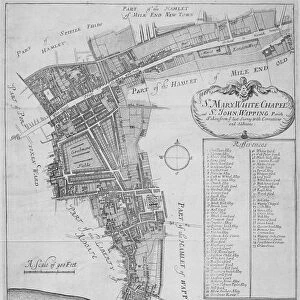
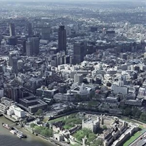
Leighs Map of London, showing the Shoreditch, Whitechapel and Wapping areas, 1818. (Photo by Hulton Archive/Getty Images)
Unleash your creativity and transform your space into a visual masterpiece!
Hulton Archive
Media ID 11795814
© 2008 Getty Images
7"x5" Glass Mount
Wall mounted or free-standing, these black edged glass frames feature a smooth chamfered edge and a stylish black border (on back face of the glass). Manufactured from 4mm thick glass, Glass Mounts are a durable, professional way of displaying and protecting your prints. Your 7x5 print is slotted into the back of the frame so can easily be changed if needed.
Tempered Glass Mounts are ideal for wall display, plus the smaller sizes can also be used free-standing via an integral stand
Estimated Image Size (if not cropped) is 12.7cm x 17.7cm (5" x 7")
Estimated Product Size is 16.2cm x 20.3cm (6.4" x 8")
These are individually made so all sizes are approximate
Artwork printed orientated as per the preview above, with portrait (vertical) orientation to match the source image.
FEATURES IN THESE COLLECTIONS
> Fine Art Storehouse
> Aerial Art
> Fine Art Storehouse
> Photo Libraries
> Heritage Images
> Aerial Photography
> England
> Aerial Photography
> Related Images
> Europe
> United Kingdom
> England
> Aerial Views
> Europe
> United Kingdom
> England
> London
> River Thames
> Europe
> United Kingdom
> England
> London
> Towns
> Docklands
> Europe
> United Kingdom
> England
> London
> Towns
> Shoreditch
> Europe
> United Kingdom
> England
> London
> Towns
> Wapping
> Europe
> United Kingdom
> England
> London
> Towns
> Whitechapel
> Europe
> United Kingdom
> England
> Maps
> Europe
> United Kingdom
> England
> Rivers
EDITORS COMMENTS
This print showcases the historic "Map of London" created by Leigh in 1818. The image provides a mesmerizing aerial view of the Shoreditch, Whitechapel, and Wapping areas, offering a glimpse into the city's rich past. As we delve into this intricate map, we are transported back to a time when London was undergoing significant transformation. The Tower of London stands tall amidst its surroundings, symbolizing both strength and resilience. Tower Hill and the adjacent docklands come alive with bustling activity as ships navigate through the River Thames. This iconic river serves as a lifeline for trade and transportation, connecting various parts of the city. Every detail on this map tells a story - from street names to landmarks that have shaped London's identity over centuries. It is fascinating to observe how urban development has evolved since 1818 while still preserving some historical elements that continue to define these neighborhoods today. As we explore this remarkable piece of artistry captured by Hulton Archive/Getty Images, it becomes evident that maps not only guide us physically but also provide glimpses into our collective heritage. This particular print allows us to appreciate England's capital city in all its glory during an era marked by growth and change
MADE IN THE UK
Safe Shipping with 30 Day Money Back Guarantee
FREE PERSONALISATION*
We are proud to offer a range of customisation features including Personalised Captions, Color Filters and Picture Zoom Tools
SECURE PAYMENTS
We happily accept a wide range of payment options so you can pay for the things you need in the way that is most convenient for you
* Options may vary by product and licensing agreement. Zoomed Pictures can be adjusted in the Basket.