Glass Frame > Europe > United Kingdom > England > Hampshire > Portsmouth
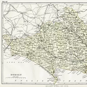
Glass Frame : Map of South East England, Hampshire, Dorset, Wiltshire 1891


![]()
Mounted Prints from Fine Art Storehouse
Map of South East England, Hampshire, Dorset, Wiltshire 1891
Antique Map of Map of South East England, showing Hampshire, Dorset, Wiltshire, and the Isle of Wight 1891
Unleash your creativity and transform your space into a visual masterpiece!
duncan1890
Media ID 15245285
© duncan1890
Channel Dorset Uk English Channel Equipment Hampshire England Image Created 1890 1899 Navigational Equipment Northern Europe Portsmouth England Road Map Southeast England Southwest England Styles Wiltshire Image Created 19th Century Obsolete Retro Styled Victorian Style
7"x5" Glass Mount
Wall mounted or free-standing, these black edged glass frames feature a smooth chamfered edge and a stylish black border (on back face of the glass). Manufactured from 4mm thick glass, Glass Mounts are a durable, professional way of displaying and protecting your prints. Your 7x5 print is slotted into the back of the frame so can easily be changed if needed.
Tempered Glass Mounts are ideal for wall display, plus the smaller sizes can also be used free-standing via an integral stand
Estimated Image Size (if not cropped) is 17.7cm x 12.7cm (7" x 5")
Estimated Product Size is 20.3cm x 16.2cm (8" x 6.4")
These are individually made so all sizes are approximate
Artwork printed orientated as per the preview above, with landscape (horizontal) orientation to match the source image.
FEATURES IN THESE COLLECTIONS
> Fine Art Storehouse
> Map
> Historical Maps
> Fine Art Storehouse
> Map
> Map Illustrations
> Europe
> Related Images
> Europe
> United Kingdom
> England
> Dorset
> Related Images
> Europe
> United Kingdom
> England
> Hampshire
> Portsmouth
> Europe
> United Kingdom
> England
> Hampshire
> Related Images
> Europe
> United Kingdom
> England
> Maps
> Europe
> United Kingdom
> England
> Portsmouth
> Europe
> United Kingdom
> England
> Posters
> Europe
> United Kingdom
> England
> Related Images
> Europe
> United Kingdom
> England
> Wiltshire
> Related Images
> Europe
> United Kingdom
> Maps
EDITORS COMMENTS
This antique map print takes us back to the enchanting landscapes of South East England in 1891. With its retro-styled cartography, it offers a glimpse into the past, showcasing Hampshire, Dorset, Wiltshire, and the Isle of Wight in exquisite detail. The lithograph's vibrant colors bring life to this 19th-century illustration, evoking a sense of nostalgia for a bygone era. As we explore this historical gem, we are transported through time and space. From the English Channel that stretches out before us to the intricate roadways that crisscross these counties, every element on this map tells a story. It serves as both an invaluable navigational tool from yesteryears and a testament to the artistry involved in creating such masterpieces. The Victorian-style aesthetics add further charm to this image created over a century ago. It reminds us of how much has changed since then while also celebrating our rich history. This print is not just an obsolete piece; it represents an entire era with its unique style and attention to detail. Whether you have personal ties to these regions or simply appreciate historical artifacts, this antique map print allows you to immerse yourself in Southwest England's past glory. Let your imagination wander as you trace the paths taken by those who came before us and discover hidden gems waiting to be explored once again.
MADE IN THE UK
Safe Shipping with 30 Day Money Back Guarantee
FREE PERSONALISATION*
We are proud to offer a range of customisation features including Personalised Captions, Color Filters and Picture Zoom Tools
SECURE PAYMENTS
We happily accept a wide range of payment options so you can pay for the things you need in the way that is most convenient for you
* Options may vary by product and licensing agreement. Zoomed Pictures can be adjusted in the Basket.