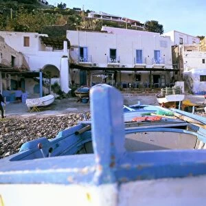
Glass Frame > Europe > Italy > Sicily > Acireale
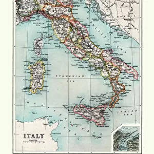
Glass Frame : Topographic map of Sicily, Italy, lithograph, published in 1897


![]()
Mounted Prints from Fine Art Storehouse
Topographic map of Sicily, Italy, lithograph, published in 1897
Topographic map of Sicily, Italy - largest island in the Mediterranean Sea. Lithograph, published in 1897
Unleash your creativity and transform your space into a visual masterpiece!
ZU_09
Media ID 35843172
Aeolian Islands Brown Catania Ionian Sea Island Mediterranean Sea Palermo Sicily Sicily Southern Europe Syracuse Italy Topographic Map Topography Trapani Province Tyrrhenian Sea Volcano Egadi Islands Etna Messina Multi Colored White Color
7"x5" Glass Mount
Wall mounted or free-standing, these black edged glass frames feature a smooth chamfered edge and a stylish black border (on back face of the glass). Manufactured from 4mm thick glass, Glass Mounts are a durable, professional way of displaying and protecting your prints. Your 7x5 print is slotted into the back of the frame so can easily be changed if needed.
Tempered Glass Mounts are ideal for wall display, plus the smaller sizes can also be used free-standing via an integral stand
Estimated Image Size (if not cropped) is 17.7cm x 12.7cm (7" x 5")
Estimated Product Size is 20.3cm x 16.2cm (8" x 6.4")
These are individually made so all sizes are approximate
Artwork printed orientated as per the preview above, with landscape (horizontal) orientation to match the source image.
FEATURES IN THESE COLLECTIONS
> Fine Art Storehouse
> Map
> Historical Maps
> Europe
> Italy
> Heritage Sites
> Isole Eolie (Aeolian Islands)
> Europe
> Italy
> Heritage Sites
> Syracuse and the Rocky Necropolis of
> Europe
> Italy
> Sicily
> Acireale
> Europe
> Italy
> Sicily
> Catania
> Europe
> Italy
> Sicily
> Messina
EDITORS COMMENTS
Discover the rich topography of Sicily, Italy, as depicted in this stunning 1897 lithograph. The largest island in the Mediterranean Sea, Sicily is a captivating blend of coastline, mountains, and volcanic landscapes. This intricately detailed map showcases the diverse provinces of Sicily, including Messina, Palermo, Syracuse, and Catania. The Ionian Sea and Tyrrhenian Sea border the island, with the Egadi and Aeolian islands adding to its allure. The towering presence of Mount Etna, Europe's most active volcano, dominates the eastern part of the map. Its fiery heart has shaped the land around it, creating a unique and breathtaking landscape. The map also highlights the vibrant cities and towns, such as Acireale, with its colorful buildings and picturesque streets. This topographic map, published over a century ago, invites us to explore the history and beauty of Sicily. With its multi-colored hues, the lithograph transports us back in time, allowing us to appreciate the island's natural wonders and cultural significance. The contrasting shades of blue, brown, and white create a visually striking representation of the island's diverse terrain. The intricate engraving and meticulous attention to detail make this a must-have for history enthusiasts, travelers, and anyone with a passion for the past. This horizontal lithograph, with its rich colors and evocative imagery, is a testament to the enduring allure of Sicily and the Mediterranean Sea.
MADE IN THE UK
Safe Shipping with 30 Day Money Back Guarantee
FREE PERSONALISATION*
We are proud to offer a range of customisation features including Personalised Captions, Color Filters and Picture Zoom Tools
SECURE PAYMENTS
We happily accept a wide range of payment options so you can pay for the things you need in the way that is most convenient for you
* Options may vary by product and licensing agreement. Zoomed Pictures can be adjusted in the Basket.