Glass Frame > Europe > France > Canton > Landes
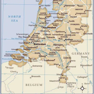
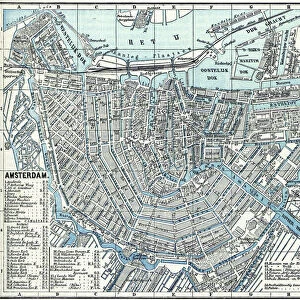
Glass Frame : Netherlands map


![]()
Mounted Prints from Fine Art Storehouse
Netherlands map
illustration of a Netherlands map
Unleash your creativity and transform your space into a visual masterpiece!
Nastasic
Media ID 13750445
© This content is subject to copyright
Amsterdam Antwerp City Belgium Atlantic Ocean Belgium Benelux Contour Drawing Country Geographic Area Dutch Culture Fax Machine Island Land Netherlands North Sea Rotterdam Serbia Storytelling Topography Utrecht Friesland Netherlands
7"x5" Glass Mount
Wall mounted or free-standing, these black edged glass frames feature a smooth chamfered edge and a stylish black border (on back face of the glass). Manufactured from 4mm thick glass, Glass Mounts are a durable, professional way of displaying and protecting your prints. Your 7x5 print is slotted into the back of the frame so can easily be changed if needed.
Tempered Glass Mounts are ideal for wall display, plus the smaller sizes can also be used free-standing via an integral stand
Estimated Image Size (if not cropped) is 12.7cm x 17.7cm (5" x 7")
Estimated Product Size is 16.2cm x 20.3cm (6.4" x 8")
These are individually made so all sizes are approximate
Artwork printed orientated as per the preview above, with portrait (vertical) orientation to match the source image.
FEATURES IN THESE COLLECTIONS
> Fine Art Storehouse
> Map
> Historical Maps
> Arts
> Artists
> O
> Oceanic Oceanic
> Europe
> Belgium
> Related Images
> Europe
> France
> Canton
> Landes
> Europe
> Netherlands
> Amsterdam
> Europe
> Netherlands
> Maps
> Europe
> Netherlands
> Posters
> Europe
> Netherlands
> Related Images
EDITORS COMMENTS
This print showcases an exquisite illustration of the Netherlands map, created by the talented artist Nastasic. With its vertical orientation and intricate details, this artwork beautifully captures the essence of this enchanting country. From the bustling cities of Amsterdam and Rotterdam to the historical landmarks in Utrecht, every corner is meticulously depicted. The map encompasses not only the Netherlands but also neighboring Belgium, Friesland, and even stretches as far as Serbia. The Benelux region comes alive through this stunning piece, showcasing a rich tapestry of Dutch culture and history. Engraved with precision using an ancient technique, this lithograph exudes a timeless charm that transports us back in time. The contour drawing adds depth to each city's topography while highlighting their significance within the country's narrative. As we gaze upon this antique masterpiece, we are reminded of how interconnected Europe truly is. The North Sea serves as a natural boundary while the Atlantic Ocean reminds us of distant lands waiting to be explored. Whether displayed in a study or living room, this illustration sparks curiosity and invites storytelling about past journeys or future adventures yet to come. It is more than just a map; it is an artistic representation that celebrates both geography and cartography at its finest.
MADE IN THE UK
Safe Shipping with 30 Day Money Back Guarantee
FREE PERSONALISATION*
We are proud to offer a range of customisation features including Personalised Captions, Color Filters and Picture Zoom Tools
SECURE PAYMENTS
We happily accept a wide range of payment options so you can pay for the things you need in the way that is most convenient for you
* Options may vary by product and licensing agreement. Zoomed Pictures can be adjusted in the Basket.