Glass Frame > Europe > France > Paris > Maps
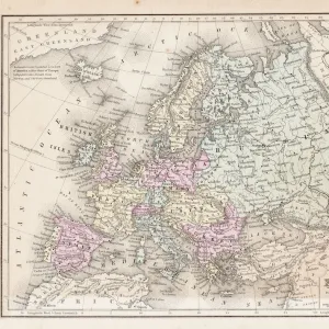
Glass Frame : Map of the Russian Empire in Europe and Asia 1780


![]()
Mounted Prints from Fine Art Storehouse
Map of the Russian Empire in Europe and Asia 1780
This is a map of the Russian Empire, a copperplate engraving from the Atlas de Toutes les Parties Connues du Globe Terrestre, Dresse Pour l Histoire Philosophique et Politique des Etablissemens et du Commerce des Europeens dans les deux Indes by Raynal and Bonne, published in Paris in 1780. Captions: Carte de l Empire de Russie en Europe et en Asia (Map of the Russian Empire in Europe and in Asia). Liv. V. No. 24. Long, du Meri, de Paris. Separate map scales are provided for Poland; the French community; marine; Dutch or German; Chinese, and Turkey
Unleash your creativity and transform your space into a visual masterpiece!
Whiteway
Media ID 15387387
© Whiteway
Copper Engraving Copperplate Engraving French Culture Image Created 18th Century Russia 1780 Russian Empire
7"x5" Glass Mount
Wall mounted or free-standing, these black edged glass frames feature a smooth chamfered edge and a stylish black border (on back face of the glass). Manufactured from 4mm thick glass, Glass Mounts are a durable, professional way of displaying and protecting your prints. Your 7x5 print is slotted into the back of the frame so can easily be changed if needed.
Tempered Glass Mounts are ideal for wall display, plus the smaller sizes can also be used free-standing via an integral stand
Estimated Image Size (if not cropped) is 17.7cm x 12.7cm (7" x 5")
Estimated Product Size is 20.3cm x 16.2cm (8" x 6.4")
These are individually made so all sizes are approximate
Artwork printed orientated as per the preview above, with landscape (horizontal) orientation to match the source image.
FEATURES IN THESE COLLECTIONS
> Fine Art Storehouse
> Map
> Historical Maps
> Asia
> Related Images
> Asia
> Turkey
> Related Images
> Europe
> France
> Paris
> Maps
> Europe
> France
> Paris
> Related Images
> Europe
> Germany
> Paintings
EDITORS COMMENTS
This copperplate engraving, titled "Map of the Russian Empire in Europe and Asia 1780" offers a glimpse into the vastness and grandeur of the Russian Empire during the 18th century. Published in Paris as part of the Atlas de Toutes les Parties Connues du Globe Terrestre, this map was created for Raynal and Bonne's comprehensive work on European establishments and commerce in both Indies. The intricately detailed illustration showcases Russia's territorial expanse across two continents, with separate scales provided for various regions such as Poland, France, marine routes, Dutch or German territories, China, and Turkey. The vibrant colors bring life to this historical artifact while highlighting key geopolitical boundaries that shaped the empire at that time. As we observe this piece from Whiteway's collection at Fine Art Storehouse today, it not only serves as a valuable resource for historians but also provides insight into French culture during the era. This map represents an important intersection between artistry and cartography—a testament to human curiosity about distant lands and their political influence. Immerse yourself in history with this exquisite copper engraving—let your imagination wander through vast landscapes dotted with cities, rivers winding through unexplored territories, and trade routes connecting civilizations. It is a window into a bygone era when empires were expanding their reach across continents—a visual reminder of our collective past.
MADE IN THE UK
Safe Shipping with 30 Day Money Back Guarantee
FREE PERSONALISATION*
We are proud to offer a range of customisation features including Personalised Captions, Color Filters and Picture Zoom Tools
SECURE PAYMENTS
We happily accept a wide range of payment options so you can pay for the things you need in the way that is most convenient for you
* Options may vary by product and licensing agreement. Zoomed Pictures can be adjusted in the Basket.