Glass Frame > Arts > Artists > B > Augustus Butler
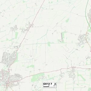
Glass Frame : Map of Ohio, Michigan and Kentucky 1881


![]()
Mounted Prints from Fine Art Storehouse
Map of Ohio, Michigan and Kentucky 1881
A System of Modern Geography designed for the use of schools and academies by Augustus Mitchell - Published by T. H. Butler / Philadelphia 1881
Unleash your creativity and transform your space into a visual masterpiece!
THEPALMER
Media ID 18357209
7"x5" Glass Mount
Wall mounted or free-standing, these black edged glass frames feature a smooth chamfered edge and a stylish black border (on back face of the glass). Manufactured from 4mm thick glass, Glass Mounts are a durable, professional way of displaying and protecting your prints. Your 7x5 print is slotted into the back of the frame so can easily be changed if needed.
Tempered Glass Mounts are ideal for wall display, plus the smaller sizes can also be used free-standing via an integral stand
Estimated Image Size (if not cropped) is 12.7cm x 17.7cm (5" x 7")
Estimated Product Size is 16.2cm x 20.3cm (6.4" x 8")
These are individually made so all sizes are approximate
Artwork printed orientated as per the preview above, with portrait (vertical) orientation to match the source image.
FEATURES IN THESE COLLECTIONS
> Fine Art Storehouse
> Map
> Historical Maps
> Arts
> Artists
> B
> Augustus Butler
> Maps and Charts
> Related Images
EDITORS COMMENTS
This print showcases a remarkable piece of history, the "Map of Ohio, Michigan and Kentucky 1881". Created by Augustus Mitchell for educational purposes, this map was an integral part of his renowned publication called "A System of Modern Geography designed for the use of schools and academies". Published in Philadelphia in 1881 by T. H. Butler, this map offers a fascinating glimpse into the geographical landscape of these three states during that era. The intricate details and precise cartography featured in this print are truly awe-inspiring. Every contour, river, city, and county is meticulously depicted with utmost accuracy. As we gaze upon this vintage masterpiece from THEPALMER collection at Fine Art Storehouse, we can't help but marvel at how far our understanding of geography has come since its creation. Beyond being a mere representation of land boundaries and topographical features, this map holds immense historical significance. It serves as a time capsule transporting us back to the late 19th century when education relied on such comprehensive visual aids to impart knowledge to students. Whether you're an avid collector or simply appreciate artful relics from the past, this print is bound to captivate your imagination. Let it transport you through time as you explore the intricacies of Ohio's rolling hillsides, Michigan's Great Lakes coastline, and Kentucky's sprawling landscapes immortalized in one stunning composition.
MADE IN THE UK
Safe Shipping with 30 Day Money Back Guarantee
FREE PERSONALISATION*
We are proud to offer a range of customisation features including Personalised Captions, Color Filters and Picture Zoom Tools
SECURE PAYMENTS
We happily accept a wide range of payment options so you can pay for the things you need in the way that is most convenient for you
* Options may vary by product and licensing agreement. Zoomed Pictures can be adjusted in the Basket.