Glass Frame > Arts > Artists > S > Syrian Syrian
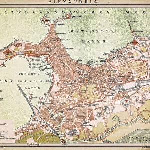
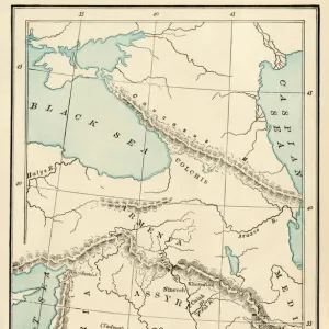
Glass Frame : Map of Napoleons Campaign in Egypt 1798 - French campaign in Egypt and Syria


![]()
Mounted Prints from Fine Art Storehouse
Map of Napoleons Campaign in Egypt 1798 - French campaign in Egypt and Syria
Illustration of a Map of Napoleons Campaign in Egypt 1798 - French campaign in Egypt and Syria
Unleash your creativity and transform your space into a visual masterpiece!
Nastasic
Media ID 18106701
7"x5" Glass Mount
Wall mounted or free-standing, these black edged glass frames feature a smooth chamfered edge and a stylish black border (on back face of the glass). Manufactured from 4mm thick glass, Glass Mounts are a durable, professional way of displaying and protecting your prints. Your 7x5 print is slotted into the back of the frame so can easily be changed if needed.
Tempered Glass Mounts are ideal for wall display, plus the smaller sizes can also be used free-standing via an integral stand
Estimated Image Size (if not cropped) is 12.7cm x 17.7cm (5" x 7")
Estimated Product Size is 16.2cm x 20.3cm (6.4" x 8")
These are individually made so all sizes are approximate
Artwork printed orientated as per the preview above, with portrait (vertical) orientation to match the source image.
FEATURES IN THESE COLLECTIONS
> Fine Art Storehouse
> Map
> Historical Maps
> Africa
> Egypt
> Related Images
> Arts
> Artists
> S
> Syrian Syrian
> Asia
> Syria
> Related Images
> Maps and Charts
> Related Images
EDITORS COMMENTS
In this photo print, titled "Map of Napoleon's Campaign in Egypt 1798 - French campaign in Egypt and Syria" artist Nastasic takes us on a historical journey back to the year 1798. The intricately illustrated map serves as a visual testament to the audacious expedition led by one of history's most renowned military strategists, Napoleon Bonaparte. The map showcases the vast territories encompassing Egypt and Syria, meticulously detailing the various cities, rivers, and geographical features that played significant roles during this campaign. As we delve into its intricate lines and markings, we are transported to an era where conquests were marked not only by battles but also by cultural exchanges between East and West. Napoleon's ambitious endeavor aimed to establish French dominance in these regions while cutting off British trade routes with India. This pivotal moment in history forever altered the dynamics of power within Europe and shaped future colonial aspirations across continents. Through Nastasic's artistic interpretation, we gain insight into the strategic maneuvers employed by Napoleon as he navigated through unfamiliar terrains against formidable adversaries. The attention to detail allows us to appreciate both the grand scale of this military operation and its impact on local populations caught amidst political upheaval. This print is not just a mere depiction of historical events; it is an invitation for contemplation about human ambition, exploration, and conquests that have left indelible imprints on our world today.
MADE IN THE UK
Safe Shipping with 30 Day Money Back Guarantee
FREE PERSONALISATION*
We are proud to offer a range of customisation features including Personalised Captions, Color Filters and Picture Zoom Tools
SECURE PAYMENTS
We happily accept a wide range of payment options so you can pay for the things you need in the way that is most convenient for you
* Options may vary by product and licensing agreement. Zoomed Pictures can be adjusted in the Basket.