Glass Frame > Maps and Charts > Africa
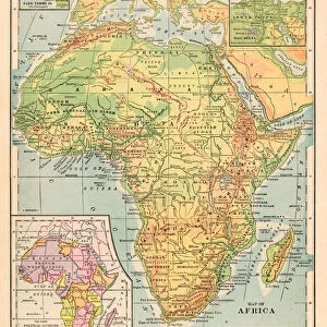
Glass Frame : Map of Africa 1889


![]()
Mounted Prints from Fine Art Storehouse
Map of Africa 1889
Comprehensive Geography by James Monteith - American Book Company 1882, 1889
Unleash your creativity and transform your space into a visual masterpiece!
THEPALMER
Media ID 18357281
7"x5" Glass Mount
Wall mounted or free-standing, these black edged glass frames feature a smooth chamfered edge and a stylish black border (on back face of the glass). Manufactured from 4mm thick glass, Glass Mounts are a durable, professional way of displaying and protecting your prints. Your 7x5 print is slotted into the back of the frame so can easily be changed if needed.
Tempered Glass Mounts are ideal for wall display, plus the smaller sizes can also be used free-standing via an integral stand
Estimated Image Size (if not cropped) is 12.7cm x 17.7cm (5" x 7")
Estimated Product Size is 16.2cm x 20.3cm (6.4" x 8")
These are individually made so all sizes are approximate
Artwork printed orientated as per the preview above, with portrait (vertical) orientation to match the source image.
FEATURES IN THESE COLLECTIONS
> Fine Art Storehouse
> Map
> Historical Maps
> Africa
> Related Images
> Maps and Charts
> Related Images
EDITORS COMMENTS
In this print titled "Map of Africa 1889" we are transported back in time to the late 19th century, when exploration and discovery were at their peak. The map, sourced from James Monteith's renowned Comprehensive Geography book published by the American Book Company in 1882 and updated in 1889, offers us a glimpse into the intricate details of Africa's diverse landscape. As our eyes wander across the aged parchment, we can't help but marvel at how much has changed since then. This vintage representation showcases a continent on the brink of transformation, with colonial powers vying for control over vast territories. It serves as a historical testament to an era marked by both curiosity and exploitation. The meticulous craftsmanship evident in every line and contour is a testament to Monteith's dedication as well as THEPALMER's skillful reproduction. The faded hues evoke nostalgia while adding an air of authenticity to this remarkable piece of cartographic history. This photograph print from Fine Art Storehouse allows us to appreciate not only the artistry behind such maps but also invites us to reflect upon Africa's complex past. It serves as a reminder that geography is not merely about borders or topography; it encapsulates stories of human endeavor, conquests, and cultural exchange. Whether displayed in homes or educational institutions, this timeless artwork sparks conversations about our shared heritage while honoring those who dedicated their lives to unraveling Africa's mysteries during an era long gone by.
MADE IN THE UK
Safe Shipping with 30 Day Money Back Guarantee
FREE PERSONALISATION*
We are proud to offer a range of customisation features including Personalised Captions, Color Filters and Picture Zoom Tools
SECURE PAYMENTS
We happily accept a wide range of payment options so you can pay for the things you need in the way that is most convenient for you
* Options may vary by product and licensing agreement. Zoomed Pictures can be adjusted in the Basket.