Glass Frame > Europe > Poland > Maps
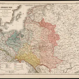
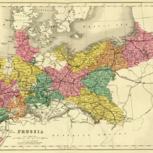
Glass Frame : Historical map of Pomerania, Germany and Poland, lithograph, published 1897


![]()
Mounted Prints from Fine Art Storehouse
Historical map of Pomerania, Germany and Poland, lithograph, published 1897
Historical map of Pomerania, German Empire (now Germany and Poland). Lithograph, published in 1897
Unleash your creativity and transform your space into a visual masterpiece!
ZU_09
Media ID 18292257
7"x5" Glass Mount
Wall mounted or free-standing, these black edged glass frames feature a smooth chamfered edge and a stylish black border (on back face of the glass). Manufactured from 4mm thick glass, Glass Mounts are a durable, professional way of displaying and protecting your prints. Your 7x5 print is slotted into the back of the frame so can easily be changed if needed.
Tempered Glass Mounts are ideal for wall display, plus the smaller sizes can also be used free-standing via an integral stand
Estimated Image Size (if not cropped) is 17.7cm x 12.7cm (7" x 5")
Estimated Product Size is 20.3cm x 16.2cm (8" x 6.4")
These are individually made so all sizes are approximate
Artwork printed orientated as per the preview above, with landscape (horizontal) orientation to match the source image.
FEATURES IN THESE COLLECTIONS
> Fine Art Storehouse
> Map
> Historical Maps
> Europe
> Poland
> Related Images
> Maps and Charts
> Early Maps
> Maps and Charts
> Related Images
EDITORS COMMENTS
This lithograph takes us on a journey through time, unveiling the rich history of Pomerania, Germany and Poland. Published in 1897, this historical map offers a glimpse into the intricate details of this region during the era of the German Empire. The print showcases Pomerania's geographical boundaries with precision and elegance, highlighting its strategic location along the Baltic Sea. The intricate lines and delicate shading bring to life the diverse landscapes that define this historically significant area. As we delve deeper into the map, we discover an abundance of cities, towns, rivers, and forests that have shaped Pomerania's cultural heritage for centuries. From bustling ports to quaint villages nestled amidst picturesque countryside; each element tells a story waiting to be explored. Beyond its aesthetic appeal lies a treasure trove of information for historians and enthusiasts alike. This lithograph serves as a valuable resource for understanding political borders at that time while shedding light on how these regions have evolved over generations. Whether you are tracing your ancestral roots or simply fascinated by cartography's ability to encapsulate history within its contours, this print is sure to captivate your imagination. It invites us to embark on an intellectual adventure where past meets present - bridging gaps between nations and cultures. With every glance at this remarkable piece from Fine Art Storehouse's collection by ZU_09, we are reminded of our shared human experience and how geography has played an integral role in shaping our world today.
MADE IN THE UK
Safe Shipping with 30 Day Money Back Guarantee
FREE PERSONALISATION*
We are proud to offer a range of customisation features including Personalised Captions, Color Filters and Picture Zoom Tools
SECURE PAYMENTS
We happily accept a wide range of payment options so you can pay for the things you need in the way that is most convenient for you
* Options may vary by product and licensing agreement. Zoomed Pictures can be adjusted in the Basket.