Glass Frame > Arts > Artists > L > Guillaume Le Testu
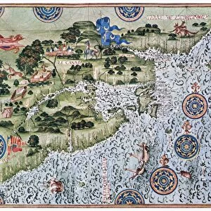
Glass Frame : Fol. 7v Map of the North Pole, from Cosmographie Universelle, 1555 (w / c


![]()
Mounted Prints from Fine Art Finder
Fol. 7v Map of the North Pole, from Cosmographie Universelle, 1555 (w / c
XIR238653 Fol.7v Map of the North Pole, from Cosmographie Universelle, 1555 (w/c on paper) by Le Testu, Guillaume (c.1509-73); Min. Defense - Service Historique de l Armee de Terre, France; (add.info.: projection en etoile a partir du pole arctique; ); French, out of copyright
Media ID 12748353
© www.bridgemanimages.com
7"x5" Glass Mount
Wall mounted or free-standing, these black edged glass frames feature a smooth chamfered edge and a stylish black border (on back face of the glass). Manufactured from 4mm thick glass, Glass Mounts are a durable, professional way of displaying and protecting your prints. Your 7x5 print is slotted into the back of the frame so can easily be changed if needed.
Tempered Glass Mounts are ideal for wall display, plus the smaller sizes can also be used free-standing via an integral stand
Estimated Image Size (if not cropped) is 12.7cm x 17.7cm (5" x 7")
Estimated Product Size is 16.2cm x 20.3cm (6.4" x 8")
These are individually made so all sizes are approximate
Artwork printed orientated as per the preview above, with portrait (vertical) orientation to match the source image.
FEATURES IN THESE COLLECTIONS
> Fine Art Finder
> Artists
> Guillaume Le Testu
> Fine Art Finder
> Maps (celestial & Terrestrial)
> Arts
> Artists
> L
> Guillaume Le Testu
EDITORS COMMENTS
This print showcases the Fol. 7v Map of the North Pole, a remarkable piece from the renowned Cosmographie Universelle created in 1555 by Guillaume Le Testu. The map, rendered with watercolor on paper, is housed at the Min. Defense - Service Historique de l Armee de Terre in France. The intricate details of this historic map are truly awe-inspiring. Le Testu's work presents a unique star projection centered around the Arctic pole, offering an innovative perspective for its time. As you gaze upon it, you can almost feel the winds of discovery blowing through centuries past. The map not only serves as a geographical representation but also features various coats of arms that symbolize different regions and their exploratory efforts during the Renaissance era. This fusion of art and cartography beautifully captures humanity's thirst for knowledge and adventure. Preserved meticulously over generations, this photograph allows us to appreciate both the artistic mastery and historical significance of Le Testu's creation. It transports us back to an age when maps were more than just navigational tools; they were windows into uncharted territories waiting to be explored. As we delve into this image, let us marvel at how far our understanding has come since 1555 while acknowledging that there is still much left to discover about our world – both within ourselves and beyond its icy horizons.
MADE IN THE UK
Safe Shipping with 30 Day Money Back Guarantee
FREE PERSONALISATION*
We are proud to offer a range of customisation features including Personalised Captions, Color Filters and Picture Zoom Tools
SECURE PAYMENTS
We happily accept a wide range of payment options so you can pay for the things you need in the way that is most convenient for you
* Options may vary by product and licensing agreement. Zoomed Pictures can be adjusted in the Basket.