Glass Frame > Historic > Ancient civilizations > Ancient Greece > Greek history
Glass Frame : 19Th Century Map Of Great Greece And Of The Islands Of Sardina And Corsica By Guillaume Delisle 1675 To 1726


![]()
Mounted Prints from Design Pics
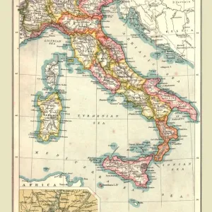
19Th Century Map Of Great Greece And Of The Islands Of Sardina And Corsica By Guillaume Delisle 1675 To 1726
Design Pics offers Distinctively Different Imagery representing over 1,500 contributors
Media ID 18188542
© Ken Welsh / Design Pics
Cartography Corsica Drawings Engravings Great Greece Greek Illustrations Islands Prints Sardinia Corsican Guillaume Delisle Nineteenth Sardinian
7"x5" Glass Mount
Wall mounted or free-standing, these black edged glass frames feature a smooth chamfered edge and a stylish black border (on back face of the glass). Manufactured from 4mm thick glass, Glass Mounts are a durable, professional way of displaying and protecting your prints. Your 7x5 print is slotted into the back of the frame so can easily be changed if needed.
Tempered Glass Mounts are ideal for wall display, plus the smaller sizes can also be used free-standing via an integral stand
Estimated Image Size (if not cropped) is 17.7cm x 12.7cm (7" x 5")
Estimated Product Size is 20.3cm x 16.2cm (8" x 6.4")
These are individually made so all sizes are approximate
Artwork printed orientated as per the preview above, with landscape (horizontal) orientation to match the source image.
FEATURES IN THESE COLLECTIONS
> Europe
> Greece
> Related Images
> Europe
> Italy
> Sardinia
> Related Images
> Historic
> Ancient civilizations
> Ancient Greece
> Greek history
> Maps and Charts
> Related Images
EDITORS COMMENTS
This print showcases a remarkable piece of cartographic history - a 19th-century map of Great Greece and the islands of Sardina and Corsica. Created by the renowned French cartographer Guillaume Delisle between 1675 and 1726, this intricate illustration offers a glimpse into the geographical knowledge of that era. The map's horizontal layout allows for an immersive exploration of these ancient lands, with every detail meticulously engraved to perfection. From the sprawling coastlines to the majestic mountain ranges, each element is brought to life through delicate drawings that capture the essence of these regions. Great Greece, known for its rich cultural heritage and historical significance, takes center stage on this map. The Greek islands are beautifully depicted alongside Sardina and Corsica, showcasing their unique topography in stunning detail. This visual representation invites viewers to embark on a journey through time as they trace the footsteps of ancient civilizations. Ken Welsh's masterful reproduction ensures that every line and contour is faithfully preserved in this exquisite print. Whether you are an avid historian or simply appreciate fine artistry, this piece will undoubtedly become a cherished addition to any collection. Transport yourself back in time with this extraordinary 19th-century map by Guillaume Delisle - a testament to human curiosity and our never-ending quest for knowledge about our world's past.
MADE IN THE UK
Safe Shipping with 30 Day Money Back Guarantee
FREE PERSONALISATION*
We are proud to offer a range of customisation features including Personalised Captions, Color Filters and Picture Zoom Tools
SECURE PAYMENTS
We happily accept a wide range of payment options so you can pay for the things you need in the way that is most convenient for you
* Options may vary by product and licensing agreement. Zoomed Pictures can be adjusted in the Basket.