Glass Coaster > Africa > Madagascar > Maps
Glass Coaster : MAP / AFRICA / MADAGASCAR


![]()
Home Decor from Mary Evans Picture Library
MAP / AFRICA / MADAGASCAR
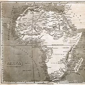
Most of the interior of the island is described as unexplored Date: mid 19th century
Mary Evans Picture Library makes available wonderful images created for people to enjoy over the centuries
Media ID 20147799
© Bubblepunk
Glass Coaster
Individual Glass Coaster. Stylish and elegant polished safety glass, toughened and heat resistant (10x10cm, 7mm thick). Price shown is per individual coaster.
Individual Glass Coaster. Elegant polished safety toughened glass and heat resistant, matching Place Mats are also available
Estimated Image Size (if not cropped) is 5.4cm x 7.6cm (2.1" x 3")
Estimated Product Size is 10cm x 10cm (3.9" x 3.9")
These are individually made so all sizes are approximate
Artwork printed orientated as per the preview above, with portrait (vertical) orientation to match the source image.
FEATURES IN THESE COLLECTIONS
> Africa
> Madagascar
> Maps
> Africa
> Madagascar
> Related Images
> Africa
> Related Images
> Maps and Charts
> Related Images
> Mary Evans Prints Online
> New Images July 2020
EDITORS COMMENTS
This map print from the mid-19th century showcases the intriguing and largely unexplored interior of the island nation of Madagascar, located off the eastern coast of Africa. The map, a testament to the spirit of exploration and discovery that characterized the era, reveals the vast expanse of Madagascar's untouched territories. Madagascar, the fourth largest island in the world, has long been a subject of fascination due to its unique biodiversity and rich cultural heritage. The map highlights the various ethnic groups and territories that inhabited the island at the time, each with their distinct languages, customs, and traditions. The interior of Madagascar, depicted in this map, remains largely unexplored even today. With its diverse topography, ranging from rainforests and mountains to deserts and plateaus, the island's interior holds countless secrets waiting to be discovered. The map provides a glimpse into the unknown, with blank spaces and rough outlines indicating the vast areas yet to be explored. The cartographic details on this map are a reflection of the knowledge available during the mid-19th century. The map's borders are not definitive, and the interior is marked with rough outlines and incomplete information, reflecting the limited understanding of the island's geography at the time. The map serves as a reminder of the intrepid explorers who braved the unknown and the vast amount of knowledge that still awaits discovery. This map print is a fascinating historical artifact that transports us back in time and offers a glimpse into the unexplored interior of Madagascar during the mid-19th century. It is a reminder of the spirit of exploration and discovery that drives us to understand the world around us and the mysteries that lie within.
MADE IN THE UK
Safe Shipping with 30 Day Money Back Guarantee
FREE PERSONALISATION*
We are proud to offer a range of customisation features including Personalised Captions, Color Filters and Picture Zoom Tools
SECURE PAYMENTS
We happily accept a wide range of payment options so you can pay for the things you need in the way that is most convenient for you
* Options may vary by product and licensing agreement. Zoomed Pictures can be adjusted in the Basket.