Glass Coaster > Arts > Landscape paintings > Waterfall and river artworks > River artworks
Glass Coaster : Map of Marquettes Explorations


![]()
Home Decor from Mary Evans Picture Library
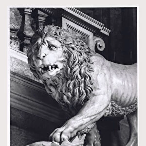
Map of Marquettes Explorations
A map of Jacques Marquettes missionary journey up the Mississippi river towards New France. A small dotted line marks the route there up through Green Bay to the Mississippi, and a dashed line marks the way back to Lake Michigan, passing the Portage copper mine. Date: 1673
Mary Evans Picture Library makes available wonderful images created for people to enjoy over the centuries
Media ID 23090226
© Mary Evans Picture Library
1673 Colonialism Colony Jacques Journey Maps Michigan Missionary Mississippi Marquette
Glass Coaster
Individual Glass Coaster. Stylish and elegant polished safety glass, toughened and heat resistant (10x10cm, 7mm thick). Price shown is per individual coaster.
Individual Glass Coaster. Elegant polished safety toughened glass and heat resistant, matching Place Mats are also available
Estimated Image Size (if not cropped) is 7.6cm x 4.5cm (3" x 1.8")
Estimated Product Size is 10cm x 10cm (3.9" x 3.9")
These are individually made so all sizes are approximate
Artwork printed orientated as per the preview above, with landscape (horizontal) orientation to match the source image.
FEATURES IN THESE COLLECTIONS
> Arts
> Landscape paintings
> Waterfall and river artworks
> River artworks
> Europe
> France
> Lakes
> Related Images
> Maps and Charts
> Related Images
> Maps and Charts
> World
> North America
> Related Images
> Mary Evans Prints Online
> New Images August 2021
EDITORS COMMENTS
This map print, dating back to 1673, illustrates the exploratory journey of Jacques Marquette, a renowned French missionary and explorer. The map marks the route Marquette took as he traveled up the Mississippi River towards New France, with a small dotted line tracing his path. Marquette's mission was to spread the Catholic faith among the indigenous peoples of North America and establish colonial outposts for the French. As Marquette ventured further north, he discovered the passage from Lake Michigan to Green Bay, which is denoted by a dashed line on the map. This significant discovery allowed Marquette and his companions to access the rich natural resources of the region, including the copper mines at the Portage. The map provides a fascinating glimpse into the early colonial history of North America, showcasing the exploratory spirit and determination of Jacques Marquette and his fellow French missionaries. The map's intricate details and meticulous annotations reflect the advanced cartographic knowledge of the time, making it an essential historical document. This map is a testament to the rich cultural exchange that took place between European explorers and the indigenous peoples of North America during the colonial era. It serves as a reminder of the profound impact that exploration and discovery had on the world during this period, shaping the course of history and expanding our understanding of the globe.
MADE IN THE UK
Safe Shipping with 30 Day Money Back Guarantee
FREE PERSONALISATION*
We are proud to offer a range of customisation features including Personalised Captions, Color Filters and Picture Zoom Tools
SECURE PAYMENTS
We happily accept a wide range of payment options so you can pay for the things you need in the way that is most convenient for you
* Options may vary by product and licensing agreement. Zoomed Pictures can be adjusted in the Basket.